
 Click 3D map to enlarge; click again to zoom
Ahuriri River to Lake Middleton via East Ahuriri Track
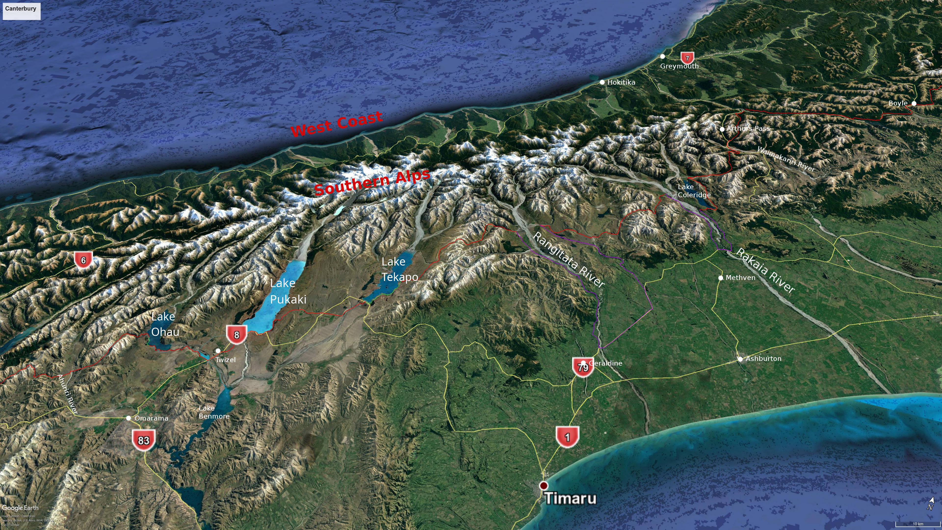
3D view north: Ahuriri River to Tekapo
23. Ahuriri River (north bank pines) to Lake Middleton: 9.5 hrs, 26 km (maps 131, 130)
It is a long hike to Lake Middleton if you started at Top Timaru hut, so you will need to stop somewhere. Camping just north of gridline 5080, about 4 km from the Ahuriri River, is suggested on the official TA notes. And there is a derelict musterers’ hut (East Ahuriri Hut, aka Quailburn Hut) on the other side of the Ahuriri River East Branch from the track 9 km up from the pines by the Ahuriri River, which will offer shelter in bad weather (see Otago notes for more). The going is quite difficult up the East Branch valley as there is no defined track and markers are far apart. Stop when you get to a marker and scan the horizon carefully for the next one, as there is no guarantee the trail continues in the same direction. The tussock is especially thick in places. Don’t follow the river when it veers to the left as you approach the pass – the track climbs steeply to the right to a plateau. Travel is easy once you get down into bush close to the lake on the other side. There is a marked camping area in a grassy area to one side of the bush but it is well spread out, so look around before picking a spot. The track later becomes a cycle track. If you follow it all the way it takes you to the Lake Ōhau Lodge, 3 km north, which offers hotel style accommodation, a restaurant and bar. This is cycling country and you could arrange to pick up a bike at the lodge from an operator further north (see under section 25 for some names).
But if you are not going to the lodge take care to turn off the cycleway down to the lake where the track, signposted as Tarnbrae Track, is marked with poles. At the lake front turn right, cross a bridge and a little further along find the track between the road and the lake. Lake Middleton, a small lake inland from Lake Ōhau.
- Lake Middleton campsite – This DoC campground has toilets and tap water (requiring treatment before drinking). Bookings not required. There is an honesty box near the main road entrance further along for your fee ($10 as of 2025). The TA Trail Pass covers this. A major wildfire in 2020 burnt some of the pine trees here, so I’m not sure what the place looks like now. It was idyllic when I visited in 2016.
Lake Middleton to Tekapo: 98 km, 3–4 days
24. Lake Middleton to Twizel: 7.5 hrs, 30 km (maps 130, 129, 128)
This is an entirely flat section that is very exposed to sun, wind, rain, or whatever the weather pleases to bring. After a short section of road walking you join the Alps to Ocean (A2O) Cycle Trail around the lake. At the lake outlet this trail is up higher on a flood route. When you skirt Lake Ruataniwha there are a couple of diversions marked with poles that get you closer to the turquoise waters of the lake. The second is certainly worth taking, even though it makes the route longer. It includes a hard-to-spot marker between two river terraces in a gap in the trees. There is a lovely area through here that is perfect for a rest or camp.
After you turn left at the highway and cross the bridge there are rough trails either side of the road that give you a bit of separation from traffic. Closer to Twizel the one on the left becomes more developed and goes behind a row of trees to insulate you from a busy stretch of road.
Twizel has a medium sized Four Square supermarket (27 Market Place) and an outdoors shop (Southern Alps Outdoors) in the shopping mall where you can buy gas. There are also restaurants and cafés in the mall.
- High Country Lodge and Backpackers – 23 Mackenzie Drive, Twizel, 03 435 0671, info@highcountrylodge.co.nz. This has a range of accommodation from bunk rooms to motel style units. They will hold food parcels for you. Website not secure (at Sept 2025), but you can book on Booking.com where a dorm bunk is $64 and double rooms from $120. Price I was quoted on phone at same date only $32 for a bunk though (11 Sept 2025). I have alerted them to the website problem, so things may change.
- Twizel Holiday Park – 122 Mackenzie Drive, Twizel, 03 435 0507.
- Mountain Chalets – Wairepo Rd, Twizel, 0800 629 999; 03 435 0785.
Twizel to Tekapo
I will give two options for getting to Tekapo. The first, which was the official route when I did this bit of the TA, goes well up the Pukaki Lake edge and then over Braemar Rd via the historic Telegraph Hut. There are some lovely (if not legal) camping spots along the lake and the tiny 2-bunk historic Telegraph Hut. Admittedly it is along a dusty road, but traffic is very light.
The new route follows instead a canal from just before the Pukaki Power Station all the way to Tekapo. It does shorten the overall distance by 13 km, and avoids a long stretch of road walking, but it comes with a problem: it is 55 km from Twizel to Tekapo without a break on a barren landscape. No camping is permitted along the canal, though there is an Airbnb at Irishman Creek station, about halfway across and there is a camping area (Pylon Campsite) about 23 km from Twizel, before you get to the canal. The official notes are silent on how long it will take you from Twizel to Tekapo in one go, but lets say 14 hours walking time, a duration that I think is beyond the ability of many hikers. Camping at The Pines at the base of Lake Pukaki would knock 12 km off the 55, but the McKenzie District Council warned the TA Trust in 2019 that camping here was not permitted. The current notes and map imply you can camp there though. Probably a better bet in terms of spacing out your days is the Pylon Campsite. I have no idea what it is like. Barren I expect.
Indeed, people did seem to camp all round the shores of the lake when I was there in 2016. I don’t think this was or is legal, and the Mackenzie District Council is big on regulating freedom camping (there are designated sites around the lake for campervans, but they must have on-board toilets). So take your chances. If there is still a long-drop at The Pines then I don’t see why you couldn’t camp here. But I think you’d need to be well secluded from officialdom elsewhere and have the ability to bury your human waste well away from streams or the lake edge. There is a also a toilet and picnic tables at the corner of Hayman Rd and the Tekapo-Twizel Rd. The TA Trail goes right past it and if you could camp here (I’m not saying it is legal) you would save 19 km off the Twizel to Tekapo section.
Cycling has become big in the Mackenzie High Country in recent years and another option might be to hire a bicycle between Lake Ōhau or Twizel and Tekapo. Companies are now catering to TA hikers who want a respite from walking and include Alps 2 Ocean (0800 425 772), Cycle Journeys (0800 224 475), and Bespoke Bike Tours (021 151 3742). You can potentially cycle all the way from Lake Ōhau to the start of Richmond Trail that heads up to Boundary Hut. It certainly does seem like a logical way of dealing with the canal route to Tekapo, provided you are not determined to actually walk the entire TA. And one option could even be to still walk, but to pay one of the companies to carry your gear, as they are often doing that with cyclists anyway. Fifty-five km with only a few things in your pack, or a day pack, might still be tough, but certainly more do-able.
Old Route
25. Twizel to Lake Pukaki camping (near Morgans Island, grid ref 1376 5112): 6 hrs, 26.5 km (maps 128, 127,–, 125)
Again you follow the A2O cycle trail over exposed flat areas with no water. At the lake spillway you cross the road to Lake Pukaki and a well formed track continues. The track along the southern shore is occasionally marked with orange poles, but it seems to disappear at times, or the bank falls away where the track formerly was. Once you start up the eastern side of the lake it is road walking all the way, with tar seal to the power station and then gravel. There are numerous idyllic camping spots amongst trees on the lake edge all the way up. In fine weather you could easily spend another day here.
26. Lake Pukaki opposite Morgan’s Island to Telegraph Hut (2 bunks): 7 hrs, 28 km (map –)
Further road walking takes you to the turn-off of Braemar Rd (4 hrs, 15 km). Then it is a bit of up and down across rolling country along this gravel road to Telegraph Hut (3 hrs, 13 km). There is very little traffic on the road. Telegraph Hut is very basic (no toilet) and, as it sleeps just two, you may not find a space. However, probably not so many TA hikers bother with the Tekapo to Twizel route, as they just see a lot of road walking (which it is, but the lake-side camping makes it worthwhile). A way to avoid sleeping at Telegraph Hut would be to walk further up the lake the previous day nearer the turn off, and then walk all the way to Tekapo (26.5 km) in one day. Or simply camp near the hut.
27. Telegraph Hut to Tekapo township: 3 hrs, 13.5 km (maps –, 125)
This is straightforward road walking, though you can cut the corner once you see traffic on the main road from Pukaki to Tekapo and head across unfenced land toward the point there the power lines to your left converge with the shelter belt of pine trees in the distance. Once you do have to walk alongside the main road there is very little road margin and a lot of traffic. You may wish to duck down to the lake as soon as you can. This will take you directly to the motor camp. The YHA is a bit further along the lake front, near the town centre.
New Route
25. Twizel to the Pines campsite: 3 hrs, 13 km (maps 128, 127)
Again you follow the A2O cycle trail over exposed flat areas with no water. At the lake spillway you cross the road to Lake Pukaki and a well formed track continues. There is grove of pine trees by the spillway with toilets (13 km north of Twizel) known as the Pines campsite. It seems to be a popular spot for campervans, but campers and campervans can be found all round the shores of the lake. It is supposed to be for self-contaned campervans, but people do stay in tents.
26. The Pines camp site to Tekapo: 42 km (maps 127, 126, 125)
Stock up on water. Continue around the southern shore of Lake Pukaki. The track is occasionally marked with orange poles, but it seems to disappear at times, or the bank falls away where the track formerly was. Then continue up the eastern side of the lake on the road. About 1.5 km after you pass the main road turning off to Twizel, a track branches off at right. Take this for 10 km and you then join up with the canal through to Tekapo. About 2 km from the start of this track is the Pylon campsite. The water in the tank here comes from the canal, so should be filtered, boiled or treated. This is 23 km from Twizel and 32 km from Tekapo. Take care crossing SH8 when the canal intersects with it. When you get to Tekapo Power Station cross over the footbridge and stay on the road going east. It becomes Andrew Don Drive and then Aorangi Crescent as it runs into the village.
If you are cycling you probably want to avoid the track to the canal. In this case, after 5km past the main road going to Tekapo turn right onto Tekapo Canal Rd and to the canal end. Stay on the south side of the canal. There are toilets 3 km along and then at another 1 km. Those are the last toilets before Tekapo. This route does not add any extra kms compared with taking the track.
Tekapo
Tekapo is on the tourist trail, with many package tours either stopping overnight or for a meal. So there are numerous restaurants and cafés, and some hotels, but both can suddenly fill up when a coach stops. The main attractions of Tekapo besides the view up the lake are the lake-front Church of the Good Shepherd and the sheepdog memorial close by. There is also the Mt John Observatory, with both daytime tours and night time stargazing (not cheap). Tekapo is within the Aoraki Mackenzie International Dark Sky Reserve, where light pollution is strictly controlled to enable exceptional views of the heavens at night. Most accommodation, and all the shops and eateries, are right on the lake front. Tailormade Backpackers is 300m back from the shops but has extensive lawn and trees. Remember to get some cash out ($10) to pay for staying at Camp Stream Hut (even if you are camping there you are still using the water and toilet).
- Haka House Lake Tekapo – 5 Motuariki Lane, 03 740 0426. This specially constructed YHA hostel closed in late 2021 not long after opening due to lack of international visitors but is now operating as a Haka Hostel. Great lakefront site.
- Tailormade Backpackers – 9-11 Aorangi Crescent, right on the TA route, 03 680 6700, 027 680 6700 (text).
- Lakes Edge Holiday Park – 2 Lakeside Drive, 03 6806 825 or 0800 853 853. Has dorm rooms, family rooms, cabins, motel units, and camping. Was once a nice spot amongst the pines, then they were all chopped down to make a barren desert.
- Lakes Edge Lodge, backpacker accommodation, same address and contact details as above.
- Annie at Bespoke Bikes can receive bounce boxes. Bespoke Bikes, 16 Murray Place, Tekapo, 021 151 3742.
Tekapo to Rangitata River via Two Thumb Track: 72.5 km, 4 days
3D view north-west: Tekapo to Rangitata River
28. Tekapo township to Camp Stream Hut: 9 hrs, 34 km (maps 124, 123)
Walk along the lake front to the corner where the road branches away south-east. There is a TA sign here, but there is also a plethora of tracks for day strollers amongst the trees and it is easy to take the wrong one. Resist the temptation to go uphill. The map is a bit misleading, but try and stay close to the lake. Then you join the road and it is more road walking like Lake Pukaki, though with less traffic. You eventually reach a car park on the left after about 4 hours (16 km from Tekapo), and the track up the hill is 1-200m further on. It is marked Richmond Trail and this takes you up into the Te Kahui Kaupeka Conservation Park. There is strictly NO camping all the way up to Boundary Stream.
The climb is steep at first, and then you turn left and walk along the mountainside, eventually intersecting the road to a ski field. Here marker poles lead you down to the left towards the lake a little (not, as shown on the TA and NZ Topo maps, uphill). The hut further on is well up a spur between two streams below, but there is a hose delivering water at the edge of the spur.
- Camp Stream Hut – Basic 6-bunk private hut. Like other huts on this section, Camp Stream Hut is a former sheep musterer’s hut and is very basic. It is not a DoC hut and not covered by the Trail Pass. There is an honesty box for your $10 contribution to keep the hut being made available to TA walkers. PLEASE take some cash for this. The owners of the hut have reported they are only collecting an average of 30 cents per visitor! There are a few tiny holes in the roof and bound to be rats, so put your food out of reach. With sheet iron cladding, deteriorated lining, and the high altitude, these huts can also be cold and draughty at night. But you are sleeping in historical relics.
29. Camp Stream Hut to Royal Hut (8 bunks): 5.5 hrs via ridge route, 14 km (via Camp Stream route) (maps 123, 122)
There are two options to the saddle. One is up the Camp Stream, the other is along the ridge and is now the official route. The previous route up the stream still shows as the TA Trail on the underlying NZ Topo Map, and would be preferable in bad weather. The ridge affords great views, and is a long, gentle climb up to the pass. The trail is not marked to begin with and is often indistinct on the ground, but in good visibility the way is obvious, especially as you near the saddle. To reach this route you take the 4WD track up to the left that is marked Rex Simpson Memorial Hut soon after Camp Stream Hut, and turn off it at right when you are on the ridge. Before the final peak on the ridge, Beuzenberg Peak, you turn off to the right to join up with the valley track to Stagg Saddle. The saddle is 1925m, the highest point on the TA, but you could always hop up Beuzenberg to get even higher (2070m). This is much easier if you took the ridge rather than the stream track on the way up. (The peak’s name was only assigned in 2007, in memory of mountain guide Erica Beuzenberg who died in a 2005 climbing accident near Ball Pass.) It is then 1.5 to 2 hrs downhill through lightly poled tussock country to Royal Hut.
- Royal Hut – Basic 8-bunk DoC hut. Free to stay. With unlined, corrugated iron walls, and situated at an altitude of 1300m, expect it to be cold at night. The hut is so named because Prince Charles and Princess Anne visited it as young adults in 1971. Don’t imagine that you might be sleeping in a bed once graced by a royal body, let alone have endured the same hike to the hut though: they were choppered in by air force helicopters, had a look around, a cup of tea, and flew out.
30. Royal Hut to Crooked Spur Hut: 6.5 hrs, 15.5 km (map 122)
Royal Hut to Stone Hut (8 bunks, similar to Royal Hut): 1 hr 45, 6 km
Stone Hut to Crooked Spur Hut: 4 hr 45, 9.5km
There is a steep climb in scree to the 1500m saddle before the hut and then a reasonably easy descent down through tussock to the hut, which is positioned on a spur to give a great view down Bush Stream to the Rangitata River. It may be difficult at times to find the orange marker poles above the spiky and often impenetrable matagouri bushes. Choose your own route based on the river braids as you find them. And make sure you turn away to the left of Bush Stream fairly soon after Stone Hut.
Apparently some people take the Forest Creek Track 2km on the right after Royal Hut down to the Rangitata. It comes out about 4 km down river from the Bush Stream exit (and 2 km down the road from Mesopotamia Station). It is about the same length as the Bush Stream Track. There is a hut called Felt Hut about half way. It is probably a musterers’ hut. I gather that some believe it is an easier route, but I don’t know.
- Crooked Spur Hut – Basic 8-bunk DoC hut. Free to stay.
31. Crooked Spur to Rangitata River: 3 hrs 25, 9 km (+ river crossing of 2.5 hrs) (maps 121, 120)
There is a steep descent down to Bush Stream, then an equally steep climb up the other side, followed by a final descent to the stream. Then is it a case of following the stream down all the way, crossing it several times, until you reach the car park on the Rangitata Gorge Rd. If you have wandered off the track somewhat, the car park is marked by rocks piled on fence posts. Your options then are:
Crossing the Rangitata River if it is low and staying at Potts Lodge or camping on the other side; hitch hiking down the Rangitata Gorge Rd (traffic is very light) or catching the mail van either to the Peel Forest DoC camp ground (about 50 km downriver), or to Geraldine, which has more accommodation options and a supermarket and is another 22 km south-east from the camp ground; or staying at Mesopotamia Station, only 30 mins (2.5 km) walk down the road. Mesopotamia is redolent of history, as it was originally founded by Samuel Butler who wrote the famous fantastical satire Erewhon (‘Nowhere’ spelt backwards) in 1872. His homestead is long gone, but its site is marked at the school house grounds. Staying at Mesopotamia Station means a very long 11.5 hr hike the next day to Mānuka Hut, but it was an accommodation highlight for this writer (and Mt Potts was booked out).
It is about 60km downriver to the nearest bridge over the Rangitata, between Peel Forest and Geraldine (50 and 70 km from Mesopotamia Station respectively) and about 75km from the bridge up to Potts River on the other side. The mail van runs occasionally from Peel Forest to Mesopotamia Station but can’t take a group. It goes on Tues and other days if there is mail. A koha is suggested. The TA guide says to contact The Green Man eatery at Peel Forest to connect up with the mail van, but this place closed some years back, and its replacement, The Parasol, closed down as well. An alternative is to stay with the Peel forest Homestay and ask them to pick you up from the trail end. If you can get to Peel Forest then a service from there to Geraldine is operated by the Geraldine Community Vehicle Trust on demand ($24 at Oct 2025, no minimum number passengers, but best to book 2 days ahead), 03 693 1007, admin@geraldinevehicletrust.nz. And Alps2Ocean (0800 425 772) offer a shuttle service on demand from the trail end itself on the south side of the Rangitata River to Geraldine. The TA notes say that an Uber service will be available from 16 Dec 2025 out of Geraldine – but there is no cellphone reception at the trail head.
- Mesopotamia Station – 4909 Rangitata Gorge Rd, RD 20, Peel Forest, 03 696 3738, info@mesopotamia.co.nz. There have been a number of reasonably priced accommodation possibilities here, which might depend on how many are in use by farm hands. Food parcels will be held for you at no charge if you are staying.
- DoC Peel Forest Camp – Peel Forest Rd, Peel Forest Park, RD 22. You now have to book online. There are 4 cabins, showers, cook house and many campsites.
- Peel Forest Homestay – 33 Rangitata Gorge Rd, about 1.2 km upstream of Peel Forest. On lifestyle block, catering to all budgets, including backpacker accommodation and they offer transport to/from the trailhead and Geraldine. 03 6969 3509, 027 305 0400 (Steve), 027 746 7267 (Jenny), sjdeans1@outlook.com.
- Geraldine Top 10 Holiday Park – 39 Hislop St, Geraldine, 03 693 8147, 0800 393 693.
- Alps 2 Ocean – Operates transfers from Camp Stream to Geraldine. The more people you have the cheaper it is, so best to team up with some others. Arrives about 10am dropping off SoBos at Camp Stream. Transfers to Mt Potts on the other side of the river, either direct, or from Geraldine, available also. And they can hold food parcels for you if you use their service. 0800 425 772.
-
Brian Mowat-Gainsford – Offers transfers around the Rangitata River, from Bush Stream carpark to Potts River trail end. b.mowatg@gmail.com, 022 069 3981.
The Rangitata is classed as a Hazard Zone on the Te Araroa website and not part of the trail, so cross the river with caution, remembering the fate of Dr Andrew Sinclair, New Zealand’s Colonial Secretary, who was drowned in 1861 attempting to reach Butler’s homestead. Not to mention the fact that river drownings were known as the New Zealand death in the early days of European settlement, as it was a common way to die before rivers were bridged. Check the present river level on the Environment Canterbury (ECAN) website (click on ‘River flow data’ and then the ‘Southern Region’ tabs). The flow reading, as with the Rakaia, is not actually at the point where you might want to cross, being well downstream, but the graph gives a relative indication and if you click on the 30 day readings you can get a sense of where the river is presently at (unfortunate that there seem to be no annual charts, as that would be more useful, though it may be helpful to know that the mean annual flow is 95 cubic metres/sec at Klondyke). There are no markers, and there are many braids of the river to cross. It can take about 2.5 hrs to cross from the car park on one side to the one on the other. The river level has been known to rise fast during the time it takes to cross – a hiker had to be rescued by helicopter in the 2022-23 season for this very reason. Crossing above where the Potts River feeds in should reduce the amount of water a bit. Mt Potts Lodge is a further 3 km up the road to the left from the car park on the other side.
Mt Sunday, a high point on the northern river bed not far up from Mt Potts Station (grid 1429 / 5176) got its name because boundary riders from the various high country sheep stations used to meet here on Sundays. It was the site of Edoras in the Lord of the Rings films.
- Mt Potts Lodge – 2131 Hakatere Potts Rd, Ashburton Lakes, 03 303 9060, 027 238 1813, mtpottslodgenz@gmail.com. It has bunk rooms (a single bunk over a double for $120 (at at Nov 2025), a cottage and deluxe rooms (both expensive) and camping (with outdoor kitchen shelter), plus café and restaurant. They used to hold food parcels but it would pay to check what the current situation is. Note that the café, restaurant and possibly reception are closed Tuesday and Wednesday. Breakfast and dinner need to be booked in advance.
Rangitata to Rakaia River via Hakatere Conservation Park: 72.5 km, 3 days
3D view north-west: Rangitata River to Rakaia River
32. Mt Potts Lodge to Mānuka Hut: 9.5 hrs, 35.5 km (maps 120, 119, 118)
The first section in the Haketere Conservation Park is along the Clearwater Track from the Haketere Potts Rd car park to Buick’s Bridge on the Haketere Heron Rd (5 hrs 15, 20.5 km from the car park). Camping is permitted along here, though there is no shelter on the route. A possible camping option might be at the start, at Haketere Potts Rd car park, where there is some degree of shelter. From the bridge it is road walking along an unsealed road and then the Clent Hills Track that begins at a gate onto a farm road on the Castle Ridge Station. You need to keep to the road over the farmland to Lake Emily. Then it is down a steep bank to the hut (3 hrs, 12 km from Buick’s Bridge). The whole route from Mt Potts to Mānuka Hut is mostly easy walking and clearly marked, but it is very exposed and a long day.
- Mānuka Hut – Basic 6-bunk DoC hut. Free to stay.
33. Mānuka Hut to Comyns Hut: 7.5 hrs, 21km (maps 118, 117)
Mānuka Hut to Double Hut 6km; Double Hut to Comyns Hut 17 km.
The first hour and a half of this track is easy going, passing Double Hut 1 km off to the left, and then it is a steep climb up to a saddle, followed by a certain amount of up and down through tussock as the track tries to stay clear of the valley floor containing the Swin River North Branch below. The route is clearly marked most of the way. Eventually you reach the Clent Hills Saddle (1480m) opposite Round Hill. The descent down to Comyns Hut follows Round Hill Creek and then the North Branch Ashburton River. The river valley is narrow at times and the going becomes very rough and difficult, as well as slow. The route is rarely marked, there are numerous stream crossings, and dense matagouri discourages travel on the river banks. High river flows would make the route very difficult indeed.
- Comyns Hut – Basic, 8-bunk DoC hut. Free to stay. This is another tin hut with a concrete floor and consequently may be cold at night. There are rats present, so hang your food out of reach.
34. Comyns Hut to Glenrock Stream car park, Rakaia River: 4.5 hrs, 16 km (map 116)
The route to Double Hill Run Rd by the Rakaia River is easy and along 4WD tracks that pass the A-Frame hut (3-4 bunks) on the way to Turtons Saddle. Then it is a steep zig-zag down from the saddle. It’s a great view out over the Rakaia from the saddle, and you may be able to watch south-bound TA hikers puffing their way up.
The Rakaia is another river stated by the official TA guide to be a Hazard Zone and crossing it is not part of the trail. Most people take this warning seriously, for the river has about two to three times as much water flowing down it as the Rangitata, though crossings have been done in low flows. This is in no way a recommendation, but if you are going to try it you really should be experienced in such things, be of large build, and have at least one companion. It would make sense to head up river a bit, as the Wilberforce joins the Rakaia just south of the car park, so you could avoid the combined flow of two rivers by taking them separately. If you cross the Rakaia and then go up or across the Wilberforce River north of Mt Oakden you will end up at the head of Lake Coleridge and have saved yourself a tedious bit of road walking around the lake, but will also have skipped a bit of the TA trail. Mind you, river bed walking is tedious and difficult in its own right.
Rather than risk losing their life, most people opt to travel down river 48 km to stay and resupply at Methven (two supermarkets and a hardware store that sells some camping supplies) and then go back up the other side. Or go 32 km as far as the Rakaia Gorge Bridge, where there is a camping ground and cross over there before coming back up the other side to Lake Coleridge Village (46 km from Methven). Take the Zig Zag Rd immediately after the bridge on the north bank to save walking time. There is relatively little traffic down the south bank for hitch hiking, but more going up to Lake Coleridge. An alternative is catching a ride on the school bus with Methven Travel in the late afternoon Monday to Friday after the children have been dropped off home. Departs Glenrock trail head at about 4.30pm. You will need to check times with the company, and find out if it is summer school holiday period or not (see Links page for school terms). The cost is about $35, bookings essential.
The further alternative is to arrange a ride with Alps 2 Ocean. Note, however, both for this and the school bus, that there is no cellphone reception either at the car park or above on Turtons Saddle, so you need to organise them well ahead.
- Glenrock Station – Double Hill Run Rd. Turn left on the road when you cross it and go 1.5 km. The station is on the left. Farm cottage with special TA rate of $60. 03 318 5855, text txt 027 311 9106, andykate@netspeed.net.nz (Confirmed correct Oct 2024)
- Methven Camping Ground – 77 Barkers Rd, Methven, near the town centre. 03 302 8005; 021 0818 5546; 021 259 9504. Camping and cabins (special TA rate for latter) and accepts supply boxes.
- Snow Denn Lodge – 6 Bank St, Methven. Dorms and single rooms. Special rates for TA walkers, bookings essential. Resupply boxes held for $5. 03 302 8999, snowdenn@xtra.co.nz.
- The Brown Pub – cnr Main St and Forest Drive, Methven. $59 for single room, $109 for twin, $119 king, etc (as at Sept 2025). 03 302 8045.
- Big Tree Lodge – 25 South Belt, Methven. 10% discount for TA walkers for phone bookings. No charge for bounce boxes. Can arrange transport. Peter Wilson 029 0201 2762, jiaxingyuki@gmail.com. (Confirmed correct Oct 2024)
- Methven Lodge and B&B 182 Main St, Methven. 03 302 9047.
- Rakaia Gorge Camp – 6686 Arundel Rakaia Gorge Rd, 021 251 1817. The camp ground has tent sites, a sheltered cooking area, showers, toilets and water. Website says there is no power (and little cellphone reception) but there is hot water (gas heated? Or do they just mean there are no powered campsites?).
- Alpine Sports – Hiking supplies, etc. 87 Main St, Methven. Open 7am to 7pm daily. For dehydrated meals, gas, hiking shoes, etc. 03 302 8084.
- Hammer Hardware – 85 Main St, Methven. Also have camping gas and supplies. 03 302 9664.
- Methven Travel – 160 Main St, Methven, for shuttles to Christchurch and the school bus run up the Rakaia River. 0800 684 888; 03 302 8106, 027 437 5432 (Dave).
- Alps 2 Ocean – Operates transfers to Methven and/or around to Harper Rd or Coleridge Village. 0800 425 772, 027 439 4662 (text is best).
- Selwyn Shuttles – Do regular runs to Lake Coleridge Village (and up the other side of the Rakaia on demand) from Methven for TA hikers. 021 776 968 (Brad).
There is no camping permitted in the Lake Coleridge area except at the head of the lake at Harper Village. Nor are there any shops at either Lake Coleridge Village or Harper Village. However, Coleridge Village is a pleasant place for a stay (see below) and is full of history concerning the hydroelectric dam, which was completed in 1914, the first government hydro scheme in NZ. The village was built to house workers and it even had a demonstration house to show off the benefits of electricity in the home.
- Lake Coleridge Powerhouse Lodge – 114 Hummocks Road, CMB 18, Lake Coleridge Village, 022 081 0882. Open late-November for Te Araroa Trail walkers. Bookings not necessary. Tent sites, bunkrooms and lodge options. Wi-Fi, outdoor kitchen, hot showers, washing facilities and snacks available. Bounce boxes can be received and held. The Lodge is also the pickup and drop off point for the Methven Shuttle.
Coleridge to Arthur’s Pass: 74.5 km, 3 days
3D view north-west: Rakaia River to Bealey
35. Lake Coleridge Lodge to Harper Campsite: 8.5 hrs, 29 km (maps 115, 114)
The route out of Lake Coleridge Village begins on the road just above the Lake Coleridge Lodge. It goes through an arboretum planted in 1933 that contains an extensive collection of conifers from around the world. You then pass the hydro scheme’s penstocks and end up on a road at the top of the hill.
After a short distance there is a downhill stretch across farmland to the lake. Note that the trail is marked to the right of the 4WD track and the landowner expects walkers to keep to the trail. At the bottom of the hill the trail goes through two swamps while the 4WD road skirts them. If no-one is about you can avoid getting wet feet by taking the farm road around at least the first, wetter, one, as the road detour is very minimal. From here you join an unsealed road and it is a long, mostly flat, slog around the lake with little shelter. There are toilets at Lake Georgina (about 11.5 km from Lake Coleridge Village) and Lake Selfe (another 11 km further on). In the weekend a lot of vehicles pulling boats at high speed will pass you by. It is a pretty unsafe road to be walking beside. When you have descended the last stretch, turn left into the village and then left over a wooden bridge and follow the sign that says 2 km to the lake. A short way down on the left is the Harper Campsite. No cellphone reception, but some signal is available at or above the village and to the start of the Harper River track (the next section) for One and Two Degrees network users.
Harper Campsite – Free campsite with a shelter, toilet and a water tap. A rather barren spot, but pines down one side offer some shelter. Built by Trustpower (now Manawa Energy), who run the Lake Coleridge Power Station. Any queries contact helen.stanger@trustpower,co.nz 03 318 5700.
36. Harper River campsite to Hamilton Hut: 6.5 hrs, 19 km (maps 114, 113)
Continue back up the road that took you to the camping area, but don’t cross the wooden bridge again. You will go over a concrete bridge and then you will need to climb over the gate where the road turns off to the left. There is no indication of a trail until you come to a new fence and a sign directing TA walkers to divert right around it. This differs from the map, but the walking is easy. When the diversion ends, marker poles appear up the valley. Don’t follow the 4WD track away from the river to left. Nor think that the large valley to your right is your destination. Things are a little disorienting where the Avoca River joins the Harper, as there are valleys on the right and the way up the Harper Valley is not obvious from further down. The land is on Glenthorne Station and you are asked to strictly stick to the trail. Cross the Avoca and then the Harper. Back from the valley a little at the point where the map shows the Harper River crossing are The Pinnacles, strange geological formation of pillars of eroding soft rock each protected by a stone cap. 4WD tracks appear and then end in river fords up much of the rest of the river. There is a 4WD track well to the right and above the river that leaves the river bank just below and opposite The Pinnacles. That’s where you are supposed to go or risk being trespassed! Hamilton Hut is up Hamilton Creek to the right and over a suspension bridge. Kea frequent the hut and you will see the approach to the hut strewn with shredded plastic items – a reminder not to leave your belongings outside.
- Hamilton Hut – Serviced 20-bunk DoC hut. Bookings required.
37. Hamilton Hut to Greyneys Shelter (& thence to Arthurs Pass): 7.5 hrs, 25.5 km (maps 113, 112)
The first half hour is easy walking before you start up the Harper River bed itself. The route is marked with stone cairns here and there. Do your bit and build up the crumbling ones. Watch out that you don’t go up the Fall Creek valley. The route takes a bit of a left turn here and an orange triangle marker only comes into view when you have made the turn. West Harper Hut (1.5 hrs) is a very basic tin hut with earth floor and canvas bunks. The Lagoon Saddle A-frame Hut (3 hrs 40) is a more modern affair, but very basic and only sleeps 2 (as of 2019 mattresses may have been removed and a notice to say ‘no overnight stays’ put up). There is another tiny tin hut that looks like a garden shed nearby, across the creek in the forest, with two bunks but no mattresses. From the A-frame it is a short distance up to Lagoon Saddle, where there is a panoramic view of the Waimakariri River valley below. It can be rugged weather up here, as suggested by the names of the peaks to your right, Mt Misery and Mt Horrible. However, it is easy walking downhill to Bealey Hut (1 hr 50) and on to the main highway connecting the east and west coasts via Arthur’s Pass. You could easily stay at Bealey Hut (6 bunks), but it will only have taken 5 hrs 40 to get here (not the 7-8 hrs in the TA notes, which is partly accounted for by the long slog up to Lagoon Saddle going north to south), so you could push on to Bealey Hotel (50 mins), Greyneys Shelter (2.5 hrs), or Arthur’s Pass.
It is a 5 min walk to the Cora Lynn car park, and a bit further down the road to SH73. The turn off to the left on the way down takes you to Arthurs Pass Eco Lodge. It’s road walking all the way on a busy road to the Bealey Hotel. This was once the major stop on the West Coast Rd that was built to connect Christchurch to the West Coast after gold was discovered there, though the original hotel is long gone. A modern building hasn’t brought cellphone coverage with it though.
The next section, should you chose to walk it, is the Klondyke Track. It is not really usefully marked at any point, nor is it evident on the ground (because, I suspect, most TA walkers don’t use it), so you have to follow the map as best you can. It involves fording the Waimakariri River. If this is too high, then you may as well just walk along the road and across the bridge. The point where the route departs from SH73 past Bealey Hotel is not clear, though the official NoBo notes suggest at the hotel itself. A hiker suggests that this may be to the right of the building, where you walk behind two moa sculptures and along a mown path to the top of a knoll. To the right and downhill a gap in the beech trees takes you to the river plain. It is very rough, unpleasant going all the way. Make your aim point Klondyke Corner campsite, 8 km south of Arthur’s Pass village, which you may be able to locate in the distance by the white shapes of campervans. It is a basic campsite with a shelter, bookings required. Then it is walking parallel with the road and river from a gravel path at Klondyke Corner up a bank to the right along a trail in the beech trees with yellow markers. However, erosion has removed the track in places, so you either have to bush bash or descend to the river. You cross a railway line and continue on an unsealed road parallel to the main road to pass Greyneys Shelter. The shelter itself is more enclosed than Klondyke, and you could sleep on the benches within the shelter at a pinch in bad weather but camping is not permitted. And anyway, you are probably best to hitch hike to Arthur’s Pass, 6km away. The road is very busy with tourist traffic, and narrow, so road walking would not be safe.
Arthur’s Pass has a café and store that sells some groceries, but I wouldn’t count on there being much of use as it mainly caters to campervan tourists. You could certainly buy a sandwich for lunch the next day though. There is a restaurant across the road with main dishes in the $20 to $30 range, and mediocre takeaway fish and chips. A DoC visitor centre sells camping gas and is a good place to get a weather forecast (don’t rely on them having gas in stock on the day you are there, though maybe they will hold one for you if you call in advance: 03 318-9211, arthurspassvc@doc.govt.nz). There is a large basic DoC campsite (Avalanche Creek Campsite) with ten tent sites, a large shelter for cooking and toilets on the Bealey River side of the village by the restaurant. This tends to be full of campervans. As Arthur’s Pass is on a major tourist route and is a small settlement, accommodation can be very tight. Reservations are strongly recommended for Bealey Hotel or the Youth Hostel. Note that the Mountain House reception closes at 7pm and DoC closes at 5pm. DoC have a comprehensive brochure on Arthur’s Pass. The Arthur’s Pass New Zealand website is a mine of information. Click on the menu item for the Te Araroa Trail.
If you didn’t send a food parcel ahead and you need supplies then it’s a long ride out to Greymouth on the West Coast, or Christchurch going east. The good thing is that there is plenty of transport and traffic. You could even travel in luxury on the TranzAlpine train. There are the Global Village backpackers (03 768 7272) and Noah’s Ark Backpackers (027 315 7448) in Greymouth.
Note that there are very few places you can send a food parcel ahead to now in Arthur’s Pass, and the store there has a very limited range of food, so you need to think out how you are going to resupply.
- Arthurs Pass Eco Lodge – 027 675 1511, helen@arthurspassecolodge.co.nz. Run by a DoC ranger, Helen Nugteren. $165 for two, B&B.
- The Bealey Hotel – SH 73 12858 West Coast Rd, Arthur’s Pass, 03 318 9277. Backpacker and motel type accommodation, a restaurant and bar. $225/night cheapest option for a studio room (king bed or 2 singles). Bounce boxes are no longer accepted.
- Mountain House Arthur’s Pass – 84 West Coast Road, Arthur’s Pass village, 03 318 9258, mountainhouseap@gmail.com. Formerly a YHA hostel. Bounce boxes are no longer accepted here either apparently, but I would double check this. It seems a bit mean spirited if true. The official TA notes say they sell Backcountry Cuisine meals, but again I would check ahead on that.
- Airbnb – there are three Airbnb’s at Arthurs Pass as at October 2021. None are cheap for just one person, but could work out well for a group.
- Avalanche Creek Shelter Campsite – Arthur’s Pass Village, bookings required, tent sites $15/person. The Arthur’s Pass New Zealand website advises against camping in a tent here due to the risk of kea shredding your tend and gear. Be aware also of thieves targeting tourists both here and at Klondyke Corner.
- There are also two motels at Arthur’s Pass: Arthur’s Pass Alpine Motel (03 318 9233) and the more expensive Arthurs Pass Motel & Lodge (03 318 9099 and on Booking.com).
- YMCA Arthur’s Pass Outdoor Education Centre – Oriented to large groups but dorm beds and private rooms available Oct–Feb. 83 West Coast Road, Arthur’s Pass village. They were accepting bounce boxes for $10 (with pickup only 9am to 5pm) but I’m not seeing anything about this on their website now. Best to check. 03 034 8460.
- Arthur’s Pass Lodge – NZ Alpine Club Lodge. Bunkroom accommodation. You need to book online in advance in order to get a door code. $20 for NZAC members, $40 for others.
- Nigel Marx – has a modest self-contained hut in Arthurs Pass that is often, but not always, available. nigelmarx@yahoo.co.nz, 027 537 4686. (confirmed correct Oct 2024)
- Rata Lodge – State Highway 73, Otira. If you strike out with accommodation at Arthurs Pass you could try this place at Otira, which is 13 km west of Arthurs Pass. There is nothing else at Otira. It is a strange place for a hostel, but I guess it takes the overflow from Arthus Pass for those with wheels to get there. Listed on Google at Sept 2025 as temporarily closed but that’s because it is only open 1 Nov to April.
- Atomic Travel – No longer offering scheduled services. Perhaps this may change?
- East West Coaches – 10.10am to Christchurch and 4pm to Greymouth. 027 201 8825.
- KiwiRail TranzAlpine train – Departs daily from Arthur’s Pass to Greymouth at 10.50 am. And to Christchurch at 4.35 pm. Fares vary a lot, depending on bookings.
Arthur’s Pass to Boyle: 104 km, 5 days
3D view west: Bealey to Kiwi Hut via Deception-Mingha Track
38. Greyneys Shelter to Upper Deception Hut: 6 hrs, 11.5 km (maps 112, 111)
The Deception–Mingha Track is a tough route, and unsafe after heavy rain, and some people chose to avoid it. You begin this section by getting your feet wet crossing the Bealey River. It is straightforward up the Mingha River valley to Goat Pass, the only issue being a time consuming detour over Dudley Knob to avoid a narrow section. Mingha Bivvy (3 hrs) has 2 bunks, and is a good spot for camping. Goat Pass Hut (20 bunks) is a modern hut with a short-wave radio a further 1.5 hrs over the pass. There are some spectacular mountain peaks above the track that seem almost fictional in their steepness. Then it is down the notorious Deception River. This will be an impossible route after heavy rain, so it is a good idea to get a weather forecast at Arthur’s Pass and get an update for travel further down if necessary via the radio in Goat Pass Hut. The upper section is effectively a clamber over boulders down the stream bed, making for very slow progress (but at least you aren’t going uphill). It is about 1.5 hours to Upper Deception Hut, an older style of hut which is hidden in the bush at right, so you need to watch for the sign.
Note that the Deception River is on the annual Coast to Coast Race that’s held in early February and you won’t want to be there when hundreds of trail runners come up it. The Upper Deception Hut and the Klondike Corner campsite will also be unavailable and Arthurs Pass accommodation will probably all be booked out.
One option to make the Deception–Mingha Track easier is to leave the gear you don’t need at Arthurs Pass. Then when you come out at the other end of the track cross the Morrison Footbridge and hitchhike back to Arthurs Pass, pick up your gear, and hitch back again (or on to Aickens car park – the road between the footbridge and Aickens is narrow and dangerous to walk alongside). See above for The Sanctuary shuttle option.
- Upper Deception Hut – Basic 6-bunk DoC hut. Free to stay.
39. Upper Deception Hut to Kiwi Hut: 10 hrs 45, 26 km (maps 111, 110)
Upper Deception Hut to Morrison Footbridge: 12 km
The route down the Deception River soon becomes much easier as the valley widens but it still takes 5 hours to reach the Morrison Footbridge over the Ōtira River. From here you have a choice of clambering up and down bluffs over a muddy and very poorly maintained Flood Track (though it is mostly well marked) or walking over boulders down the Ōtira River, which is equally time consuming but the obvious alternative unless the river is high. The TA map shows the Flood Track route (I guess to be on the safe side if the river is too high to traverse), and on paper it appears flat and easy. however, it is notorious amongst TA hikers as the worst on the South Island TA, so you have been warned. Possibly the easiest alternative might be to cross the Morrison Footbridge and travel down alongside the road (I don’t know how easy this is) to the Windy Point corner and Aickens car park (just north of the horizontal grid line 5264), and cross the Ōtira River on the line marked on the map. There are markers for the crossing.
Morrison Footbridge to Kiwi Hut: 14 km
Where the Ōtira River valley meets the Taramakau River there is a hard-to-spot orange marker at the end of a line of trees (2 hrs on the river bed route from the bridge). A track up the valley starts here but there are 4WD drive tracks all over the place and the one I took quickly petered out and ended in boggy country, so pay attention. Avoid my mistake by taking a right turn after the forest section onto a 4WD track at a marker sitting in the middle of the first stream bed you cross. This track ends shortly after the signed turn-off to Lake Kaurapataka, but you keep going in the same direction, crossing Otehake River 4km later and then walking about 800m to a sign directing you to cross the Taramakau to the inflow of Jackson’s Creek to the river. You will then find the small Kiwi Hut in bush at the end of a short track to the left about 800m further up the valley. There are several river crossings up the valley, so you need to be confident that the flow levels will make them passable (another reason to get a weather forecast at Arthur’s Pass or Goat Pass Hut). There is a DoC brochure on the area.
- Kiwi Hut – Standard 6-bunk DoC hut.
3D view north-west: Kiwi Hut to Boyle via Harpers Pass
40. Kiwi Hut to Hurunui No. 3 Hut: 8.5 hrs, 23.5 km (maps 110, 109, 108)
As the valley narrows the options for river bed walking gradually also narrow, making route picking a bit easier and progress a little quicker. Markers begin to appear also. At a scree fan near Locke Stream Hut (2.5 hrs) look for an orange triangle to centre right and cross the river to an island of bush. The hut (18 bunks stacked 3 high) is in here. This and three other huts on the track have historic significance. They were constructed as part of a government scheme in the 1930s to make the Harpers Pass Track an affordable alternative to the Milford Track, but it never worked out. Locke Stream Hut was made from scratch with hand sawn and adzed timber and it is worth having a look inside to see the construction and read the information panels. This was hut number 4 out of 5 built. The only other remaining one is Hurunui number 3, which you will come to next.
Two and a half hours will get you to the top of Harpers Pass (962m), an early route used by Māori and later Europeans to get to the West Coast before the Arthur’s Pass route came into use. It is hard to believe that cattle were driven over the steep approach up to the pass. The orange Harpers Pass Bivvy is a little further along, and then Cameron’s Hut, a basic tin hut with concrete floor and four bunks (2.5 hrs), though only two of the bunks may be usable (as of Feb 2021). It’s then another 1 hr 10 minutes to the comfortable Hurunui No. 3.
- Hurunui No. 3 Hut – Standard 16-bunk DoC hut.
41. Hurunui Hut No. 3 to Hope Kiwi Lodge: 9 hrs 15, 27.5 km (maps 107, 106)
It is 3 hrs of fairly easy walking to Hurunui Hut from Hurunui Hut No. 3. You could possibly make quicker progress going down the river bed than along the bush track, but there will be river crossings involved. Midway between the two Hurunui huts are well signposted hot springs, just 15 m off the track, that are worth a stop. About 30 mins after Hurunui Hut there is a suspension bridge that is easy to miss over the Hurunui River. Look behind you every now and then and if you have passed it you will spot it. Once over the river onto the Hope Kiwi Track you enter bush and wind your way around Lake Sumner without ever really seeing it and then up the Kiwi River valley to large, open grassed flats where the modern, two bunkroom hut is located. Horse riding is popular in the area and riders are supposed to take separate trails from trampers, but don’t count on it.
- Hope Kiwi Lodge – Serviced 20-bunk DoC hut. Bookings required.
42. Hope Kiwi Lodge to Boyle Village: 8 hrs, 25 km (maps 105, 104)
It is pleasant, easy walking down the side of the Hope River. Hope Shelter is a 6 bunk hut 2 hours down the track, and is really a hut rather than just a shelter. The track heads to the Windy Point car park but you need to turn left into the Tūī Track before you descend too far down the hill. It is 4 hrs 45 from Hope Kiwi to the well-marked turn-off. The Tūī Track (3 hrs 15) is easy walking through mānuka scrub and long grass. There are two river crossings, over the Doubtful and then the more substantial Boyle River. If the rivers are going to be high then you could exit at the Windy Point car park and walk along the road. The Boyle Village is simply a group of houses off the road up from the Boyle River Outdoor Education Centre and there are no shops. There is apparently a mini-tower for cellphone reception at the Windy Point car park though. An alternative for resupply is to go to Reefton, 82 km to the west or Hanmer Springs, 54 km to the east (including 10 km off the main highway), where there are shops and accommodation. Most TA walkers go to Hanmer Springs (which does have the attraction of hot pools to rest weary bodies), but you can send a bounce box to the Outdoor Education Centre and stay there.
Boyle River Outdoor Education Centre – 03 315 7082, info@boyle.org.nz. The centre is a non-profit organisation dedicated to running courses for school groups and the like but they may be able to provide accommodation at $50. This can’t be booked ahead. Note that the volunteer-staffed office is only open from 9 to 5pm and closes at 3pm on Fridays, Saturdays and Sundays, though you may be able to rouse someone up the road to come and help you. They offer storage of resupply parcels – see the centre’s Tramping Services page on its website for costs and pre-payment. Note especially that bounce boxes are to be sent to a Christchurch address (details on the ordering page). You can also order ahead gas, wi-fi access, a shower and rubbish disposal. They also sell a few basic food items.
There is also a DoC campsite with a toilet and water in the Boyle Village. Bookings required ($10). There is cellphone reception here (for Spark anyway).
- Kakapo Lodge, Hanmer Springs – 14 Amuri Avenue, Hanmer Springs, 03 315 7472.
- Hanmer Backpackers – 41 Conical Hill Rd, Hanmer Springs, 03 315 7196.
- Jack in the Green – 1 Devon St, Hanmer Springs, 03 315 5111.
- Reefton Hideaway – 20 Crampton Rd, Reefton, 022 2358 0668.
- The Old Nurses Home Accommodation – 104 Shiel St, Reefton, 03 732 8881. Single $60, share twin or double $40 per person.
- East West Coaches – 027 201 8825. Shuttles run between Westport and Christchurch Wednesday, Friday and Sunday, departing Boyle 10.20 am to Christchurch (with a drop-off at the turn-off 10 km from Hanmer), and 4.00 pm to Reefton. Drop-off at Hanmer Springs township can be negotiated for an extra fee.
- Kirsty Innes – Can also provide a shuttle service to Hanmer Springs: 03 315 7772; 027 466 7305. (Confirmed correct, Oct 2025)
- Hanmer Hiking Services – Previously offered shuttle service between Hanmer and Boyle, but this is currently on hold (as at Feb 2025). May pay to check the Facebook page for an update. 027 264 0848.
– Always check the Trail Status pages of the official Te Araroa website for recent changes or alerts on the trail.
– To download this page see instructions on the Home page.
– Make a donation to support this site.
Updated 9 November 2025
Header photo: Braemar Rd, between Lake Pukaki and Lake Tekapo
