
 Click 3D map to enlarge; click again to zoom
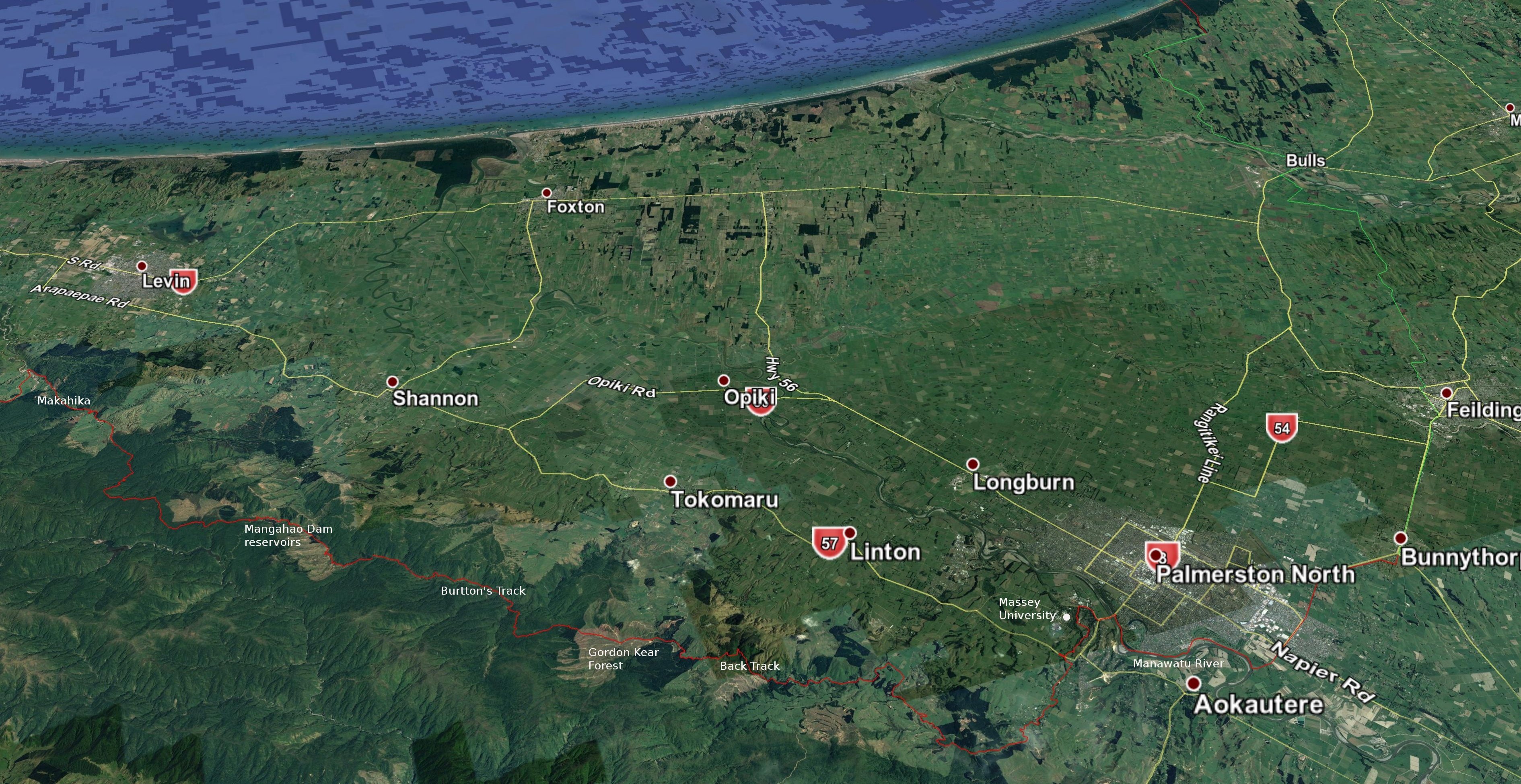
3D view north-west: Makahika to north end Burtton’s Track
9. Makahika Camp to Burttons Whare: 8 hrs 20, 25 km (maps 77, 76)
Chunking the leg from Mahahika Camp to Palmerston north is tricky. You can do it in two days, one of which will be hard. Or three days, one of which will be short. If doing it in two, then the option that makes the two days most even is to camp at Burton’s Whare site, which is about 8 hrs 20 from Makahika and then 11 hrs 15 to Palmerston North. Burton’s Whare site is not a particularly wonderful spot though: it is shady and the ground mostly slopes. The other possibility is to stay at Moturimu Whare shelter and campsite in the Gordon Kear Forest. It is about 12 hrs 15 from Makahika to the Moturimu Whare shelter, and about 7 hrs 15 from there to Palmerston North. Also, consider camping at Millblock Campsite rather than Makahika Camp. No showers there, but it will knock off about an hour from your first day.
If doing it in three days, then the official TA notes suggest going to Ian & Frank’s Hut (Tokomaru Shelter) the first night and the Moturimu Whare the second. So that would be 6 hrs 15 mins the first day, 5 hrs 20 the second, and 7 hrs 20 the third (though the official site gives 1 day, 6–7hrs, and 6.5–8.5hrs respectively). I suspect that this is what most people do, and maybe I should rearrange my notes to reflect that.
Or you could get to Burtton’s Whare site the first night and Kahuterawa Reserve picnic area the second: 8 hrs 20; 5 hrs 40; 4 hrs 50. Whew, I think I got the maths right on all these. They do all tend to add up to about 19 hours from Makahika to Palmerston North in total, so I must be right.
Makahika–Mangahao Track: 5 hrs (+ 30 mins to the start from Makahika Camp), 13.5 km
Continue north about 2 km along Gladstone Rd to the Poulton Drive parking area. Cross the stile and follow a poled route for half an hour along an unfenced right-of-way through private land that crosses the Makahika Stream. You reach the Tararua Park boundary and an information sign. Across the river is the former sawmill site. At a grassy open clearing amidst native bush about 1 hr from Makahika Camp prime minister Helen Clark unveiled a plaque commemorating the opening of the track in 2008. There is a toilet here and it makes a nice place to camp. The trail then follows the former tram-line route with benched track and cuttings clearly visible in many places. Near the terminus of the Makahika tramline formation the Bartholomew Timber Company ended native logging in this area of the Tararuas in the early 20th century.
The track departs from the tramline at right angles at a large orange marker and climbs steadily to the Makahika Ridge at around 650m, with first Kāpiti Viewpoint (Archey’s Lookout) and then the small, cleared area with seat of Horowhenua Lookout. Then there is a gradual descent, veering to the north, passing an area of revegetating mānuka on land that was once farmed. After crossing the three tributaries of Blackwood Stream (named after the black beech in the vicinity) there is another ascent, and you pass some fine examples of large rimu trees that escaped the bushman’s axe. You could potentially camp around here. On the following descent you come to an information sign and then a car park.
End of Makahika–Mangahao Track to Burtton’s Whare site: 2 hrs 50 mins, 10 km
Follow the road north along the edge of the Tokomaru No. 3 Reservoir (lake) 2.5 km to the junction of Tokomaru Valley & Mangahao Roads, then turn downhill on the Tokomaru Valley Rd. Despite the lake, the whole valley is rather unattractive and there are really no camping options in it. (Well, there is the Arapeti Campsite but it is for self-contained campervans and has no facilities.) It is about 40 mins along the unsealed country roads to a rusty white gate that marks the beginning of Burtton’s Track. After the gate on the left are some dilapidated buildings and a few hundred metres further on is Ian & Frank’s Hut. It would have taken you about 6 hrs 15 mins to here from Makahika Camp.
- Ian & Frank’s Hut (formerly Tokomaru Shelter) – Old Tokomaru Valley Rd, around about vertical gridline 1812. Has toilet, sleeping platform (no mattresses), picnic table, fresh water in a nearby stream and camping sites. It was refurbished by local members of the Te Araroa Trust. You can donate at the GiveaLittle site online to support this work.
James Burtton was a farmer who purchased a cheap block of land in the Tokomaru Valley in 1908. The local council refused to pay for constructing a road to his farm, so he did it himself with explosives and pick and shovel. The track begins as an easy, mostly level, benched route of good width through regrowth bush, following the Tokomaru River. After about 1.5 hrs nice grassy camping spots start appearing by the track. These include one at the site of Burtton’s Whare (bush hut), located within grid reference 1814/5509, just before the first of several tracks are shown on the NZ Topo map going uphill across the river.
3D view west: Burtton’s Track to Palmerston North
10. Burtton’s whare to Fitzherbert Bridge: 11.15 hrs, 40 km (maps 76, 75)
Burtton’s whare site to end of Burtton’s track: 3:15 hrs, 6.5 km
A new route has been developed for TA walkers from Burton’s Whare site. It avoids crossing the Tokomaru River twice and going over private land. You go uphill at right (east) on a series of zig-zags for 40 mins to 390m. At the top, large orange triangles mark the turn northwards. Now the track meanders down a long spur for 1 hour to rejoin the old track before crossing a stream. From here it is 2 to 3 hours slowly uphill through bush to the end of Burtton’s Track at an exposed grassy spot.
I have updated the times above to take in the extra duration of this new route, but I haven’t walked it myself, so they are estimates.
Burtton’s Track end to Back Track: 1.5 hrs, 4.5 km
The track goes downhill on a 4WD road from the stile and DoC sign at the end of Burtton’s Track. From regrowth native bush you change onto forestry roads through ugly broken country covered with the pine plantations of the Gordon Kear Forest. When I walked here in 2017, after harvest and with saplings only a few years old, the landscape was one of visual desolation, but it may look nicer now as the trees grow. Go downhill, keeping to the left at each junction. The route from here all the way to Palmerston North is generally well-marked with TA signs.
- Te Whare o Moturimu shelter and campsite – There is a new shelter by a freshwater source built at the junction of Toko Corner Rd and Centre Rd by the Palmerston North City Council within the Gordon Kear Forest. It is on gridline 5513N, at the end of what is shown as a road on the map. It is the only place you can legally camp in the forest and it is nicely placed at 28 km from Palmerston North (and 32 km from the Makahika Camp). The shelter is like a hut in the form of a wharenui (Māori meeting house) with an open door. There are sleeping platforms inside (but no mattresses).
At the bottom of the Gordon Kear Forest roads there is a locked gate and a stile and then a climb up a hill to intersect with Scotts Rd. Keep going ahead, not left, on what is now Scotts Rd, winding around the side of the hillside with mature pines below the road and farmland above. You will reach signs for Back Track on the left.
Back Track: 1 hr, 3 km
Back Track is a wide, easy track used by mountain bikers, so watch and listen out, especially in weekends, as they come hurtling down. There are a few streamlets crossing the track whose water should be good to drink. It is a steady descent, mainly through native bush, with some pine forest above, but also open farmland that allows good views over the Manawatū. At the bottom, cross Black’s Bridge to arrive at a large car park and picnic area with toilets. You could possibly camp here, but it may be frowned upon and there are better places further on.
Back Track to end of Greens Rd: 2.5 hrs, 10.5 km
The route heads now down Kahuterawa Rd following the Kahuterawa Stream. There are some nice-looking camping spots along the stream about 15 mins from the car park but they are probably on private land. However, 40 minutes from the car park there is the Kahuterawa Reserve picnic area. This is an excellent camping spot and camping is explicitly permitted. Further on, turn right into Greens Rd and after 350m take the steps down off the road at left and follow the off-road path to the top of the hill. You now re-join the road and stay on it down through open farmland.
Greens Rd to Old West Rd: 1.5 hrs, 11 km
Take the gravel road/track that descends gradually through native bush from the end of Greens Rd for 35 minutes. Watch out for mountain bikes on this track. At the bottom the trail passes the entrance on the right to the Turitea dams. Cross the bridge and follow the road for about 200m and then turn left into a track that follows the stream for 20 mins. It exits at a road bridge on Ngahere Park Rd. Cross this, then a short distance down, turn left into Turitea Rd. After a one-way bridge, a track begins again by the stream at right before joining the road once more at another bridge. Turn right and later cross over along the road when a gravel path on the left emerges. This takes a turn down what looks like a private driveway before the road begins to go up a hill. The path emerges on Old West Rd. Cross the road to pick it up again and climb up a short set of steps onto grazing land used by Massey University for farm animal research and from which there are views of the university’s Sports Institute.
If you are not planning to go into the centre of Palmerston North and wish to resupply, then you can keep on Turitea Rd (i.e. don’t cross over to the gravel path at left) and turn right at the intersection into Aokoutere Drive. There is a New World supermarket along here at left. The diversion is perhaps 800m off-trail one-way. If you are pressed for time you could skip returning to the trail and go into Palmerston North by going down Summerhill Drive from the above-mentioned intersection, though you miss some pleasant walking this way.
Old West Rd to Fitzherbert Bridge: 1.5 hr, 6km
The trail continues through open parkland, play areas and alongside bush streams. A short side trip can be taken into the Massey Aboretum after climbing down the stepped terrace where good views over the picturesque Massey University Campus are seen. The trail follows the Lower Turitea Walkway, a well-formed pathway with 3 footbridges over the Turitea Stream. You end up walking through Bledisloe Park to exit on Tennent Drive, just east of the main entrance to Massey University. There is an underpass here to take you to the other side of Tennent Drive and to continue on your direction on Dairy Farm Rd. Near its end turn right and cross the new He Ara Kotahi pedestrian bridge. Turn right on the other side and as you follow the river pass the Palmerston North Holiday Park and then the Esplanade, an extensive bushy park with pond, play area and the like. Eventually, you get to the Fitzherbert Avenue, where you turn left and head to the centre of town. (If you are pushed for time or just plain tired you could have turned right at Tennant Drive and followed it to the Fitzherbert Bridge and Fitzherbert Ave directly, saving about 2km, but via a less pleasant route.) Immediately on your left on the avenue is a drinking fountain and toilets by the play area near the car park. Buses into the centre of town stop around here too. Further into the Esplanade park is a pleasant café.
- Palmerston North Holiday Park – 133 Dittmer Drive. Some distance from The Square and supermarkets but, as noted above, it is on the TA Trail. has a good variety of cabins and ample tent sites, 06 358 0349.
- Whiowhio Hut – 20 Dorset Crescent (adjacent to the riverside walk), 027 470 9829 (please phone before arriving). Urban tramping hut. Kitchen, shower, laundry, bikes and electricity. Payment by koha (donation). Hosted by Te Araroa walkers and whio (native blue duck) enthusiasts Anthony and Fiona (aka Whinny and Whiona).
- Penny’s Accommodation – 135 Fitzherbert Ave, 0210 298 3117. Well located, on your way into the city centre. Single $117, with twins ($135) and triples available (Sept 2025 prices). Bookable on Expedia, Booking.com, etc.
- Sam’s Place – 119 Rangiora Avenue, Palmerston North. Very close to the trail as you head out of the city. Probably best to resupply at a supermarket before you get there. Sam does biker servicing but also offers tent sites for TA walkers, with showers, kitchen, toilet, wifi, etc. Click on the link ‘Tour Aotearoa rides and Te Araroa walkers’ on his home page. 021 039 0377.
- Palmerston North Motel – 66 Linton St, also well located. One of the cheaper motels. Others are Broadway Motor Inn and Aspree Motor Inn.
- Pak’nSave supermarket is on Fitzherbert Ave, just before The Square on the left; Woolworths is more-or-less on the other side, but hidden within The Plaza mall, accessible from Ferguson St or Church St. New World, mentioned above, at 198 Ruapehu Drive (off Aokautere Dr), before you get to town. Woolworths Kelvin Grove is worth considering if you are not wanting to go into the centre of the city and wish to do the Riverside Walkway (see below, but you exit later to get onto Roberts Line). And there are a couple of Asian food stores about 2-300m from The Square: Hana Mart, 199 Cuba St and Jia Hua, 517-525 Main St. Binn Inn is at 688 Main St, about 1km north-east of The Square.
Palmerston North to Bulls
The route from Palmerston North towards Whanganui (also spelt Wanganui) is a combination of pathways and road walking. Much of the road walking is on long, straight country roads. Traffic is not dense but drivers in these parts can go very fast and there is often little road shoulder. Wear something highly visible and walk on the right-hand side, facing traffic. Also note that because the route sometimes follows closely parallel roads, or routes just off the roads, it is not possible to tell from the resolution of the TA maps exactly where you should be walking at times. These notes should provide a better guide on the section from Palmerston North to Feilding than the maps.
3D view south-west: Palmerston North to Bulls
11. Palmerston North to Feilding: 6.5 hrs, 23.5 km (map 74)
For many years the TA route out of Palmerston North started back at the Fitzherbert Bridge and went along Riverside Walkway beside the Manawatū River. You exited just after the second golf course, backtracked along the Napier Road (SH3) 800m or so, and then got onto Vogel St. This is a more pleasant, if slightly longer route, but for people staying in the centre of the city it will mean backtracking down Fitzherbert Ave – though not if you are staying in the holiday park or at Whiowhio Hut. Another option is to leave the Riverside Walkway later, at the Riverside Drive carpark, to end up on Roberts Line as soon as you cross the Napier Rd. Roberts Line has footpaths up to Kelvin Grove Rd, and then good walking margins as it becomes rural. This would be my choice of routes out of Palmerston North.
The route from 2025/26 begins at Te Marae o Hine / The Square, in the middle of the city, where you will also find the library, local bus station, bus stop for InterCity buses (in the middle of The Square), toilets and i-Site. Head off from the north-west corner of The Square along Broadway Ave, the main shopping street. Turn left into Ruahine at the end of Broadway, then right into Featherston St. When this itself ends, turn left into Vogel St. You cross over the busy Tremaine Ave, with the Bunnings hardware store behind a petrol station on the left. (Just before here, on the right, is Kipling St with toilets at the Roslyn Branch Library.) Vogel St has now become Railway Road. This curves right at a roundabout to skirt the airport, then straightens up to go due north, alongside the railway.
When you get to the intersection with Roberts Line you need to turn right into that road and cross the railway line. Immediately turn left into what looks like a private drive through a farm gate and follow the line of trees parallel to the rail line. This is Sangsters Rd. Keep going in the same direction over farmland through more gates and over stiles after it ends, always staying near the fence line running beside the railway. Eventually, your path becomes Sangsters Rd again. At the intersection with Cleverly Line cross the stile into the paddock and follow TA signage to continue with the railway line to your left.
Soon you will reach the settlement of Bunnythorpe. It is known for its electrical sub-station that supplies the lower central North Island (visible off in the distance at right as you approach the village) and the historic Glaxo factory beside the road at your right. This factory was one of the origins of the large British pharmaceutical company GlaxoSmithKline. There is a dairy, toilets and a takeaway bar on your route through the village. A drinking fountain is hidden behind the toilets.
Turn left onto the Kairanga-Bunnythorpe road and cross over the rail line. Then turn right immediately on the other side. You are now on a gravel road but this runs out quickly. Keep going straight ahead, parallel with the rail line, through long grass and weeds. You will come to a crossing over Jacks Creek comprising concrete rubble. Then not far on is Mangaone Stream. Go left downstream 15 or so metres for another crossing point over rubble. Watch the first chunk of concrete – it is very wobbly! You should achieve both crossings without getting wet in normal flows. With higher water levels these will still be the best places to cross. Get onto Waughs Rd. After 2km you reach a complicated intersection and rail crossing in one. Turn right over the rail line then left into Campbell Road to again put you walking beside the railway on the less busy side – except it is on the north-east side this time. Traffic still goes very fast here, so take care. You pass Taonui (Feilding) Aerodrome and there are public toilets by the car park there. A new shared path on the left of the road starts about here.
Campbell Road is a long stretch but as it eventually turns to the left there is a crossing over the rail line to bring you to a concrete footpath beside the main road into Feilding. After 1 km take South St diagonally off to the left. And if you are headed into the centre of Feilding turn off at right on Manchester St. You will smell the Feilding saleyards as you pass them on the left, close to the centre. Farm animals are bought and sold here on Fridays, and it is worth catching the event if you are in town on the day.
- Abby & Tim trail angels – Located not far from the trail, near Manchester St school. Offer camping on their lawn and a sleepout. Can potentially pick up or drop off in the region between Palmerston North and Whanganui. 021 774 864, abbykerrin@gmail.com. (Confirmed correct Oct 2024)
- Feilding Holiday Park – 5 Arnott St, 3.2 km north-east from the Clock Tower. Has bunkroom beds. 027 607 1770.
- Timona Park, Fielding – Camping is available to TA hikers in an area adjacent to the carpark just past the toilets at the Campbell St entrance. 1.8km from the Clock Tower in the centre of town.
- Denbeigh Hotel – 50 Manchester St. Home of the Stockyard Bar (06 323 9653). Accommodation is being renovated and will become available in 2026 sometime.
The centre of town is Manchester Square that surrounds the Fielding Town Clock (on Kimbolton Rd). There is a large New World supermarket rather hidden off Fergusson St to the south-west of the Denbeigh Hotel at 42 Aorangi St, a Binn Inn at 85 Kimbolton Rd, a short distance north east of the Manchester Square, and many moderately priced restaurants and takeaway food places all centred around the Square and its offshoot streets. A generous meal can be had for $13.50 at the Sushi House Restaurant at 106 Fergusson St (it closes around 7pm). The Feilding Farmers’ Market is held every Friday 8.30am to 1pm near the Town Clock. Remember, if you are searching for Feilding on the internet, note the ‘ei’ spelling – not, as you would expect in the English language, Fielding.
12. Feilding to Bulls: 5.5 hrs, 20 km (maps 73, 72)
It is pretty much all road walking from here to the coast past Bulls. Begin by keeping on going along South St until it meets West St. Turn right into that, then left after 300m onto Ranfurly Rd through some leafy residential housing and onto the top of the hill. The road then comes down to meet Sandon Rd, where you turn left to head west. It is a 6 km stretch of reasonably busy road to Mt Biggs School.
An alternative suggested in the official notes, which is a bit longer but on less busy roads and begins with a walkway, is to turn left from South St after Manfield Park and Kowhai Park into the grounds of the latter (road is the one after Manfield Park Dr) and follow the walkway along the Makino Stream to Kitchener Park to exit on Kawakawa Rd. Turn right into that and then right again when you reach Awahuri–Feilding Rd, then left into Lees Rd. This eventually joins up with Sandon Rd about 500m before Mt Biggs School.
Turn right at the school and get onto the off-road shared pathway that runs alongside the Mount Stewart–Halcombe and then Ngaio roads to Mt Lees Reserve. There are toilets here and a tap with drinking water. Also a pleasant shelter (summer house) with a small kitchen attached. You could easily make a cup of tea here and you can camp adjacent to it or in other areas (for a donation).
Continue another 2 km to the Air-force’s Ohakea aerodrome radio station. Turn left here into Wilson Rd. Don’t go straight ahead in the same direction as Ngaio Rd at the Wilson Rd intersection. It used to be the TA route but there is no longer public access down here. The route along the river is difficult going anyway. Three km down Wilson Rd turn right onto the gravel Hurst Rd, and then left into a pleasant, sealed road, Wightman Rd. This brings you to the State Highway and the major bridge over the Rangitikei River when you turn right.
There are plenty of places to eat in Bulls as it is a transport junction, but not so much accommodation, though there is the campground as you come in and Lancewood Lodge as you exit. There is a smallish Four Square supermarket at 114 Bridge St (closes 8pm), and free wifi at the public library, with its distinctive WWI roll of honour entrance, on SH1 heading north.
- Bulls Motel and Holiday Park – 2 Bridge St, just over the bridge. Tent sites and cabins. 06 322 0894.
- Lancewood Lodge – 170 High St, Bulls (on the trail, about 600m from the intersection that marks the centre of Bulls). It previously had several accommodation options including tent sites, bunkroom and private rooms but the first two options are not listed on the website now. Best to check. 022 199 6497.
- Mayhem Roost – 48 Brandon Hall Rd, Bulls (480m off-trail). Two small huts, tent space, power, shower. $20 flat rate (incl a cold beer!) Please phone or text ahead: Mike and Jo, 027 322 1040. (Confirmed correct Oct 2024)
– Always check the Trail Status pages of the official Te Araroa website for recent changes or alerts on the trail.
– To download this page see instructions on the Home page.
– Make a donation to support this site.
Last updated 15 March 2026
