
How long is the trail?
About 3,000 km in total (it varies slightly from year to year with route changes). 1,300 km for the South Island, 1,700 for the North Island.
How long will it take to walk it?
About 2 months to do the South Island. And a little more for the North Island (the route here is longer but also easier). That’s without rest days, unexpected delays due to bad weather, injury, track closures, etc., and not going off-trail for supplies. To do the whole country in 4 months you would have to be walking hard, well planned, disciplined, and prepared for any weather. Five months might be more realistic.
When is the best time to do the trail?
Going northbound, and doing both islands, you could start in December or January. If just doing the South Island, between December and March would be fine. The most settled weather across New Zealand, with least chance of rain, is February and into March. So if you are just going to do the South Island, I would suggest beginning in late January/early February, when NZers have mostly finished their summer holidays but you have two months of the driest, most settled weather ahead of you.
Note that some Southland farm sections are closed until early November for sheep to have their lambs undisturbed. So you would have to skip these bits, take detours, or start later to work around this. Also, in November, you risk hard, icy snow being on the high passes, which can be dangerous without crampons, an ice axe and alpine experience.
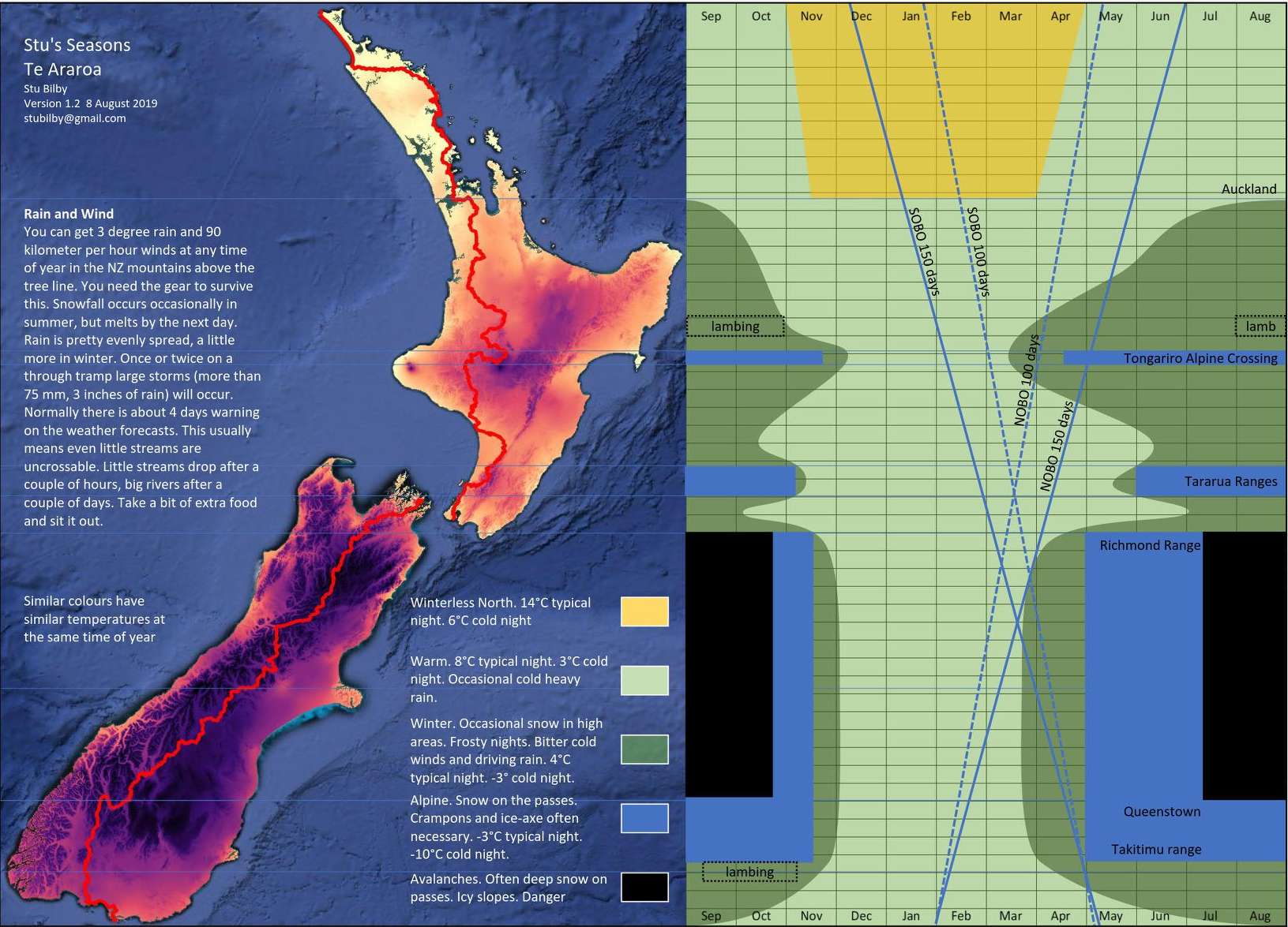
But have a look at this clever map and chart by Stuart Bilby. Print it out and chose your speed from between the super fast 100 days for the whole TA or the slower 150 days. I reckon 130 days might be reasonable (this includes about 5 non-walking days). And run a ruler parallel to either option, or somewhere between, and try some different start dates to work out missing the dark green and blue bits. Or plan around them: The Tongariro Crossing by no means necessarily has snow in April, and it is a one-day hike that is easily skipped. Ideally a rain chart could be superimposed over this as well.
What will it cost?
Probably more than you think, but it all depends on how you do the trail: whether you are always going to hitchhike and camp, or take buses and stay in backpacker hostels and motels; how often you splurge out in towns on meals and treats; how long you plan spending doing the walk (the longer you take the more it will cost you in food and accommodation); and whether you buy expensive gear specially to do the trail. See the Costs page for more information.
Is there a fee?
No, but you should make a donation to the Te Araroa Trust to help support the work that makes your hike possible. Maybe if you donated $500 per island? Plus register. Doing the Milford Track will cost you $380 or so and gets you just three days of hiking. Compare that with the Te Araroa Trail where you get a whole country and months of walking. There is an army of volunteers behind the trail, plus three paid staff. And then there are expenses for the Te Araroa Trust of signage, travel, the website, the app, and so on. You are just freeloading if you rely on other people’s donations of money and time to make your walk possible. (Oh, and consider the hundreds of hours I’ve separately put into this site too (Donate Page).)
How hard is it?
Opinions vary. Some say it is harder than the PCT in the USA. It is not a easy ‘walk in the woods’, that’s for sure. But it is something that anyone with a good level of fitness, perseverance, and some backcountry hiking experience should be able to manage. It’s not supposed to be easy of course – that would kind of defeat the purpose of it being a challenge, an achievement to be proud of when you have done it. So expect it to be hard at times. And the weather can make all the difference between pleasant and miserable.
What’s an average walking speed?
Obviously this depends on your fitness, load, and probably height, but as a rule of thumb, four km per hour on flat, even sections (like a road) might be average and a useful figure to calculate with. You might go faster when you walk the streets around your home, but when you are walking all day, carrying a pack, and needing rest stops, your average will come down to about this, or even less. On tramping tracks, 2.5 km per hour is a rough guide, but this very much depends on the track. On steep climbs, you might do only 1.5 or 1 km per hour.
I don’t want to do the whole thing. What are the best bits?
TA hikers typically list the Nelson Lakes section and the Richmond Alpine Track for the South Island. Note that you will have to walk two days from Boyle to get to the Nelson Lakes section. Also that parts of these sections are the toughest on the whole trail, both North Island and South Island. So they are both challenging, and therein lies their reward. Nelson Lakes also includes some very attractive bush and easy walking, drawing many other trampers; while the difficulty of Richmond deters the masses and you can traverse much of the section seeing few people except other TA hikers.
For the North Island, hikers often rate the Tararuas – like the Richmond, it’s a pretty rugged and challenging section. Then there is the world-famous Tongariro Crossing of course, and parts of the eastern coast of Northland are nice for a beach holiday, though the walking itself is not so interesting.
What are the hardest sections, and the easiest?
In the South Island, the Waiau Pass between Boyle and Nelson Lakes, and the Richmond Alpine Track. Both involve some steep climbs and require something of a head for heights. The Richmond section is also the longest if you are through-hiking, as it becomes the Pelorus River track with no break between, so you will be carrying a lot of weight (food) in your pack at the beginning, and the track is very rugged in parts. As for the easiest, in the South Island, maybe the Queen Charlotte Track in Marlborough that follows right on from the Pelorus River section. In the North Island? Well, there are a lot of flat sections with shops along the way.
Which is the longest section?
As above, the Richmond/Pelorus section. It is 150.5 km, or about nine days doing the whole section from St Arnaud to Havelock, though you can exit and go off-trail about half-way through.
Do I need to train to get fit before I start?
Preferably, but you can do it on the job, so to speak. It just means that you will be slow at the start and risk quitting because you find you are not fit enough. It may also mean that you won’t have had a chance to try out your gear. Footwear is a key issue. You can only find out how well a new pair of shoes or boots suit you by giving them a real workout. Body issues, like sore knees, feet, or back (from carrying a pack), may also only become apparent on a long hike, so better to identify such trouble spots before you start, when you can work on prevention, than on the trail.
Do I need back-country experience?
It helps. Quite a lot actually. Otherwise you will probably find you’ve taken both the wrong gear and too much of it, and are not well prepared for how difficult some sections are, nor how dangerous they can be in bad weather. Search and rescue parties have to be sent out to find people who have got into difficulties in New Zealand’s backcountry all the time, including more than a few TA walkers. Some people have died on the trail. Better you don’t add to the statistics.
Do I need river crossing experience or training?
Ideally, yes. It all depends on how high rivers might be when you go. That, in turn, depends on whether there is heavy rain. You may be lucky and have a pretty dry spell of weather, and only a couple of mildly flooded streams to deal with; or you may be looking at angry torrents that would knock over a horse. Best to be prepared; and when in doubt, stay out. See the Weather and Hazards page.
How do I get to the start point?
Get to Invercargill, either by flying there from elsewhere in NZ, or taking a bus from Dunedin (or maybe Queenstown). You can continue on in a shuttle bus or hitch-hike to Bluff.
What gear do I need?
As lightweight as possible. This is lighter than Kiwis typically take on a weekend tramp, so if you fall into that category you will need to do some research. Bear in mind that the weather in New Zealand can be pretty extreme and is certainly very changeable, so you need to be prepared for rain, wind and cold.
How do I resupply?
In the South Island there are a few towns along the way with good supermarkets (Invercargill, Te Anau (slightly off trail), Queenstown, Wanaka, Twizel, Tekapo and Havelock). But you will need more than this. Many people hitch-hike off-trail to the nearest large town at various points, but this uses up time and it means spending more at motorcamps or other accommodations in these towns. In the North Island you are usually not far from a store, though the stretch from Whanganui to Taumarunui has only a couple of small ones. The solution to a lack of good food shops is the bounce-box, a food parcel you send to yourself ahead of time, mailed to accommodations between sections. This needs a lot of pre-planning, but it speeds up your hike and gives you the sort of food you want, when you want it.
Where do I stay?
New Zealand, and the South Island in particular, has a fantastic network of backcountry huts that cost very little to stay in. There are a few backcountry points on the South Island trail not covered by these huts, so you will need to camp at these. And you will need to camp much more often in the North Island. As for towns and settlements, these usually have a camp ground, motels and often a backpacker hostel.
How many people will be doing the trail?
It is difficult to say, but quite a lot and it is increasing every year. In December 2025, 2,000 hikers had registered on the TA website, but this may be well under the number actually walking. I don’t imagine so many section hikers register as thru-hikers, for example. Of those registered, 21% were Nobos, but of those who completed the full hike, only 8.5% were Nobos. The latter would equate to 170 people. And they probably all started within the same two-month window, so if your intention is a full through-hike, then you would have, on average, about 2.8 people starting on the same day as you. Plus some others who are only section hiking, but who are probably spread out over a broader time period.
When are people starting?
The Sobos are starting at Cape Reinga between about 1 October and mid-December, with the bulk clustering around 2 weeks either side of late November. The Nobos are starting at Bluff around mid-November, so you would expect the two bubbles of hikers to meet somewhere around the Manawatū to Whanganui sections. Fortunately this means there won’t be any crowding of backcountry huts for NoBos, as there aren’t many huts here, though the Tararuas a bit further south might be a problem. On the other hand, if you are doing the South Island-only NoBo, and leave around 1 Feb to get the best weather and avoid the school holidays, then you will run into the SoBo bubble in the middle of the South Island for about two weeks either side of 1 March. There would be about 860 SoBos in the thru-hiker bubble, or about 14 per day if you average them out to a two-month period. That’s more than will fit into some of the backcountry huts!
Who is doing it?
Visitation to my site is overwhelmingly by New Zealanders, followed by people from Australia, USA, UK, Germany, Canada, Netherlands, France, in that order. Of those who have registered on the official site over three seasons, again the greatest number are from New Zealand, followed by USA and Germany and then a drop down to Australia, France, Netherlands, UK, Switzerland. To what extent either of these rankings reflect the proportions actually on the trail could be another story, but I’d say the general picture is about right. You can see some more statistics on the TA site.
I’m visiting New Zealand – what are the entry requirements?
You should check out the New Zealand government immigration website on this, but as a general rule you can enter NZ for up to 3 months without a visa, but you will need one for longer than this. For United Kingdom citizens you can stay for up to 6 months without a visa. Even if you are on the list of waiver countries that don’t require a visa for NZ, you will still need to get an NZ Electronic Travel Authority (NZeTA) in advance. You can get one on the immigration website. Australians don’t need a visa (or an NZeTA) to stay as long as they like.
What can I bring into the country?
Note also that NZ has strict biosecurity rules on what you can bring in. More information is on the immigration website above, but a rough guideline is that if food is processed and factory sealed it is OK. Forget about bringing in raw fruit. You will also be asked whether you have used your camping equipment recently, or been on a farm, as there is a risk of bringing in microscopic organisms in soil stuck on footwear, hiking poles, tent pegs, etc. Clean these all carefully before you arrive to avoid problems at the border. The reason why border biosecurity is important is that New Zealand is an island nation whose ecosystems have evolved without many of the organisms that occur elsewhere in the world, so introduced ones can spread like wildfire and cause huge damage. Plus the country relies on agriculture for its income.
What can and can’t I take on domestic flights?
Gas cooking canisters, methylated spirits and other flammable liquids are entirely prohibited of course. But you can take one box of matches, either in carry-on or checked luggage. In general, anything that is battery powered, or loose batteries, should be in carry-on luggage. So power banks, cellphones, cameras, e-readers, PLBs, etc should be in carry-on. The theory is that a battery fire in the cabin can be detected and put out much more easily than one in the cargo hold. Knives and other sharp items have to be in checked luggage. This includes walking poles – they are specifically listed as prohibited for carry-on by Air NZ. That is unfortunate, because a light and small pack can otherwise quality for carry-on luggage. You may be able to get away with taking them concealed in your pack on a flight to a regional airport though, because often these don’t have carry-on screening. But you would need to know in advance, because you don’t want to get told you can’t board at the last minute. The dimensions and weight limits (7kg) for carry-on are published on the airline’s websites. Generally, so long as your bag isn’t obviously oversize or overweight, Air NZ won’t check, but Jet Star will, and can be very strict about sticking to the rules. Be warned.
Can I cycle the trail, ride a horse, or take a dog?
No, no, and no. But there are some specific sections where these might be feasible. Some people hire cycles for road sections, for instance. Note that dogs are prohibited in national parks and from DoC huts, and restricted in so many other areas on the trail such as farmland that taking a dog just isn’t going to work. Long-distance walking can also be harder on them than you might think (shorter legs, no shoes and overheating issues).
Can I kayak between the North and South Islands?
No, again. Don’t even think about it unless you are a world-class, long-distance kayaker with plenty of experience in dangerous open waters. Just Google ‘most dangerous straits in the world’ and you will find Cook Strait comes up pretty quickly.
Are there any nasty bugs or critters in New Zealand?
Not really. No snakes, scorpions, crocodiles, bears, malaria, ticks, Lyme disease… So you could sleep naked under the stars and only have to worry about other people and getting cold. Clothed or not, getting cold on a mountain top and developing hypothermia is perhaps the biggest serious risk to your health. That and breaking an ankle on rough ground or falling off a cliff. There is also always a slight risk of getting the intestinal infection giardia from contaminated stream water, or the sort of bugs that circulate any time a large number of people share kitchen and toilet facilities, such as in hostels or backcountry huts. After catching a stomach bug myself from a night spent in a hostel I recommend using your own plates and utensils in such places.
What about side trips. I don’t want to visit New Zealand and just do the TA?
You could easily fit in the Kepler Track (out of Te Anau), and the Routeburn (from Glenorchy, or turn west at the Greenstone hut and go through to Glenorchy on the Routeburn that way). Both are DoC Great Walks, which means they are indeed great, but need to be booked well in advance for specific dates because they are popular and there are plenty of people on them (up to 50 in some huts when fully booked). You could head over to Stewart Island from Bluff before starting the TA too and do some tramping there (including another one of the Great Walks). In the North Island, you can easily expand on the Tongariro Crossing by doing one of the ‘round the mountain’ trips (either Ngāuruhoe or Ruapehu). There are plenty of other options along the length of the TA as well.
How do you pronounce Te Araroa?
Phonetically: teh ah-rah raw-ah. It literally means ‘the (te) pathway (ara) long (roa)’, or ‘the long pathway’ when turned into English. The ‘e’ on Te is pronounced like the ‘e’ in egg. ‘Ara’ starts like the ‘ah’ in ‘ah-ha’. The ‘r’s are softly rolled a bit, but don’t worry about that too much. Next ‘a’ is like ‘ah’ again. ‘Roa’ has a long ‘o’, like ‘or’, or you can think of the ‘ro’ as ‘raw’. And the last ‘a’ is like ‘ah’ again.
What do those words mean?
I was surprised to hear one British TA hiker say she didn’t know what ‘sidle’ meant. I hadn’t realised it is peculiar to NZ. It’s a term that appears quite often in the official TA guides, as do other sometimes obscure ones like the ‘true left’ or ‘true right’ bank of rivers. So here’s a few terms, often colloquial English, Kiwi, or trail slang, that might be a puzzle to some.
Bach – NZ term for a holiday (vacation) cottage. Derived from US term baching, meaning living like a bachelor (i.e. simply). Also known as a crib in the lower South Island.
Bivy (or bivvy) – short for bivouac, a very small and basic hut, usually with room for just 2 people, or at most 4.
Boohai (booai, booay) – a remote area (also known as the wop-wops). Probably derived from the small settlement of Puhoi (north of Auckland, on the TA). Hence, ‘Up the boohai’ – mistaken, gone astray.
Burn – a Scottish and southern NZ term for a stream.
Bush – used in NZ to refer to indigenous forest; and in Australia to back country, especially uncultivated. So there is a slight difference between NZ and Australian usage.
Bush bashing – making your way through (usually) dense bush where there is no trail.
Busted a gut – exhausted yourself. ‘Stuffed’, ‘pooped’, ‘knackered’ and ‘wiped out’ all refer to the familiar TA experience of being tired out, exhausted.
Dairy – NZ term for a convenience store. A small shop selling basics like bread, milk, newspapers, biscuits (cookies), cold drinks, icecreams, pies, lollies (candy), biscuits (cookies), chippies (crisps, chips), toilet paper, cigarettes, and a limited quantity of groceries. More expensive than a supermarket.
DoC – Department of Conservation, the government organisation that operates and oversees much outdoor recreation in New Zealand. www.doc.govt.nz
EFI – every f-king inch. Meaning walking every metre of the trail and not taking rides or skipping sections. Clearly doesn’t include getting around Lake Wakatipu, across the Rakaia River and other rivers in high-flow conditions, across Cook Strait, and up or down part of the Whanganui River. But see also HYOH below.
Freedom camp – camping in a tent, caravan, motorhome or van in an undesignated area without (usually) amenities. This is a hot topic in NZ, as some campers leave behind rubbish and human poo, and many local authorities are clamping down on it.
Gnarly – difficult, dangerous or challenging. Or great, wonderful. Or both meanings at the same time maybe.
Grid reference – these refer to the (naturally enough) grid lines that appear on the TA maps. If a location is within a square then the first number is the vertical line at the left (‘easting’) and the second is the horizontal line below its top (‘northing’).
Gully – commonly used in Australia and NZ to describe a small, narrow-sided valley. Called a ravine in the USA.
HYOH (Hike your own hike) or TYOT (tramp your own tramp) – do the trail your way. Everybody tackles a trail like the TA their own way, and that’s fine. There is no proper way to do it and you shouldn’t feel pressured into thinking there is.
Koha – Māori term for a donation, offering or present.
Long drop – NZ/Australian slang for a pit lavatory. Also, dunny, bog, shitter, shit house, etc.
NoBo – I think you know this one: trail jargon for a north-bound hiker. And SoBo for a south heading one.
Piece of piss – NZ slang for easy (‘That section was a piece of piss.’) The opposite of ‘hard yakka’ (hard work).
Portaloo – A brand of portable toilet.
Scree – mountain slope covered with small, loose stones.
Scroggin – NZ term for trail-mix. A mixture of nuts, dried fruit and chocolate or lollies for snacking on. Sounds Scottish but its origins are obscure.
Sidle – to negotiate a steep slope by moving across it.
Spur – a projection from a mountain range. So you have a ridge line along the centre of the range and spurs off the sides.
Stopbank – a NZ and Australian term for a levee, embankment or dyke. That is, a bank to stop water overflowing from a river or other body of water.
Takeaway – place selling ‘food to go’; food you take away to eat.
Tarn – a small mountain lake.
Tramping – NZ term for an extended walking expedition in bush or back country. Called bush-walking in Australia and hiking elsewhere.
True bank of a river – the true left is the left side when you look down the river in its direction of flow, and similarly for true right bank. Imagine the river as a person lying down, with its headwaters at the head and its exit to the sea as the feet.
Wee – small (Scottish)
Yeah nah – NZ and Australian slang meaning ‘no’, but in an agreeable way. Like, ‘Thanks for the offer, but no, we prefer to walk’. Can also mean agreement when the other speaker is expressing a negative: ‘Yeah nah, I wouldn’t eat that either’.
Zero – trail slang for a non-walking day. And hence Nero, a near-zero hiking day.
There are plenty of more general Kiwi slang or colloquial terms, some of which are shared with Australia or the UK: ‘Shout’ – pay for someone else’s food/drink; ‘Hundy’ – one hundred, or ‘hundyaz’ – one hundred percent keen; ‘Hard-out’ – working (or walking) really hard; ‘Half-pie’ (or ‘half-pai’) – not a very hard try, inadequate effort; ‘Kapai’ (Māori, pronounced car-pie) and ‘sweet-as’ – good, great, no problem; ‘Choice’ – good, great; ‘Chur’ – thank you, or good wishes; ‘Cuppa’ – cup of tea or tea/coffee break; ‘Smoko’ – tea/coffee break (originally including smoking a cigarette); ‘Bikkie’ – biscuit (i.e. cookie); ‘Chippies’ – crisps in the UK, chips in the USA and NZ, though chips in NZ also means French fries (as in fish and chips).
