
 Click 3D map to enlarge; click again to zoom
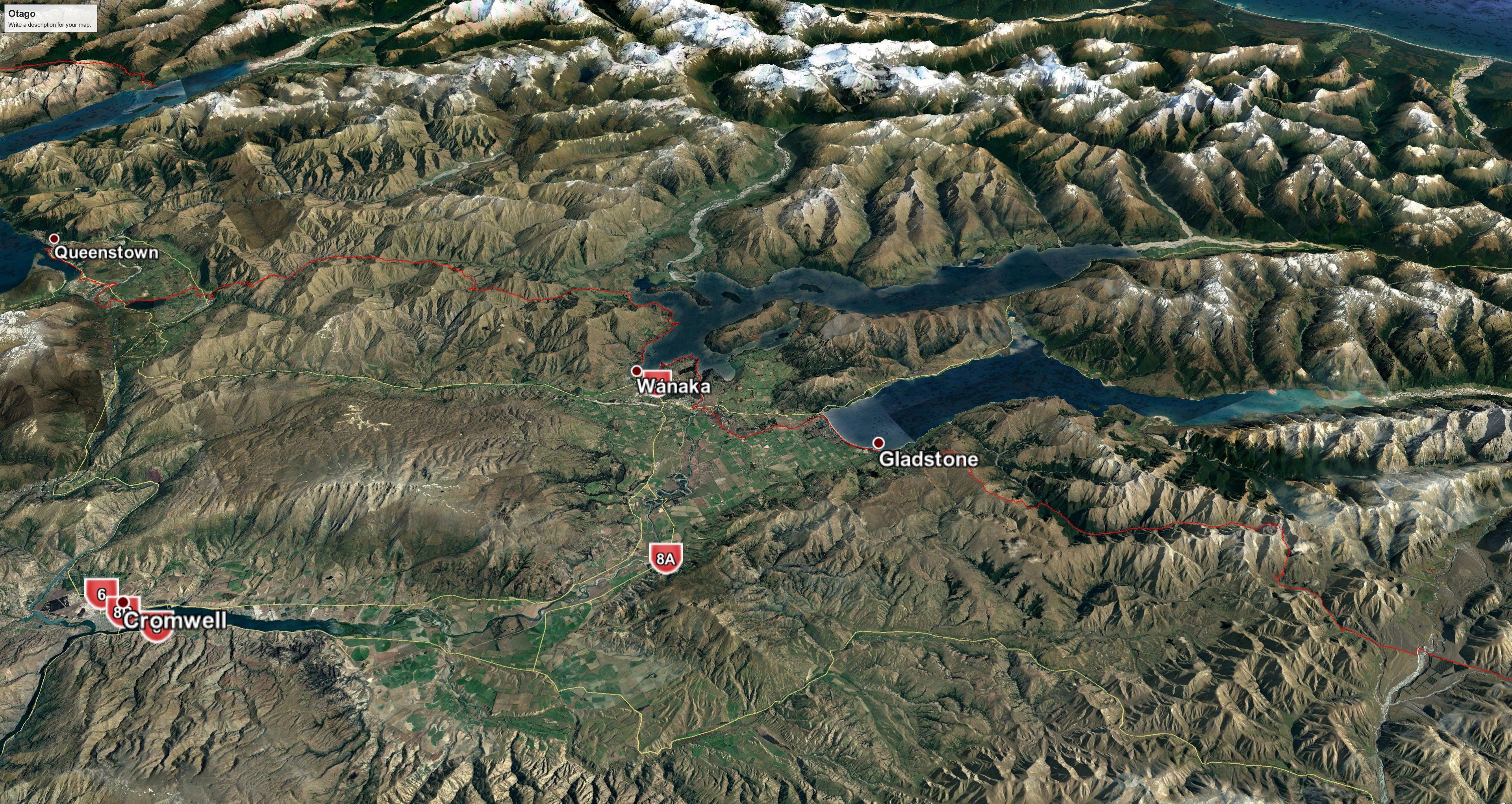
3D view west: Queenstown to Roses Hut
15. Queenstown to Arrowtown: 7.5 hrs, 28.5 km (maps 140, 139)
This section to Arrowtown follows cycle trails, but there are a number of them, and there is no TA signage. Try and stay on the Queenstown Trail. When you get to Frankton things get a bit confusing, but if you approximately follow the map it will be fine. While here you can take a detour to the shopping complex on the far side of the airport, where there is a large New World (and an outdoors store) for resupply (save you carrying more food to this point anyway), but much closer to the trail is a large Woolworths supermarket further along to your right, just before Grant Rd. You continue alongside the main road past this supermarket, and a huge Mitre 10 Mega to Glenda Drive. Go right into Glenda Drive and just when you think you are going in the wrong direction turn left into an inconspicuous lane called Margaret Place. Go down here to the Shotover River, and across the old historic bridge (past the new road bridge). Then it is a circuitous but well-signposted route to Lake Hayes that follows the river before entering a surreal subdivision known as Hayes Estate. Don’t expect to find any shops (or many signs of life) here. When you reach the main road, cross over and walk a short distance east along it to pick up the track around the lake. This ends at Rutherford Rd. Continue up that, turn right into Slope Hill Rd, then right again into Speargrass Flat Rd. A short distance along is a track to the left taking you uphill on the Millbrook Track and into another surreal experience, the perfectly manicured and very green Millbrook Resort. The route through the resort is well signposted. You end up at the main entrance road, The Avenue, an avenue (naturally), of trees leading to the main road, Malaghans Rd. Turn right into this and almost immediately take a left turn into Manse Rd. This turns into Caernarvon St. You can branch off to the left to Wiltshire St for the centre of town or continue on to Kent St. At the end of Kent St you come to a park and across that you will see the Arrowtown Holiday Park.
- Hampshire Holiday Parks – Arrowtown – 12B Centennial Avenue, 03 442-1876. This appears to be the only cheap accommodation in Arrowtown. There is a small supermarket near the camp ground that staff can direct you to (at 32 Adamson Drive). This might save you carrying food from Queenstown, but bear in mind that the choice is more limited and expensive. Arrowtown is a gentrified tourist town, so offers little in the way of general supplies, though there are plenty of cafés and restaurants.
- Arrowtown Night n Day Food Store – 39 Buckingham St, Arrowtown.
- There is an Orbus bus that goes every hour (or half hour in ‘rush-hour’) between Queenstown and Arrowtown, so you could always leave your gear at Queenstown, walk to Arrowtown and bus back, and then bus to Arrowtown the next day.
Arrowtown to Wānaka via Motatapu Alpine Track: 63.5 km, 3–4 days
16. Arrowtown to Roses Hut: 9.5 hrs, 23 km (maps 139, 138)
The next section takes you over several reasonably high passes and through an abandoned settlement to another tourist town, Wānaka. The Motatapu Track is exposed and physically demanding and only suitable for experienced trampers. There is little or no water above the valleys and conditions can be very hot and dry in summer but the possibility of wintry conditions exists at any time of year.
Arrowtown Camp Ground to Macetown: 4.5 hrs
From the camp ground head north-west via Cardigan St, followed by Hertford St, then turn right into Wiltshire St and left into Buckingham St through the centre of town (or go further down towards the Arrow River and walk along Ramshaw Lane). You will see riverside parking and picnicking areas where Ramshaw meets Buckingham. Head west by the river and you will see the river route around to Macetown along a 4WD track. You could take this if the weather higher up is not going to be good (there is also an exit point up the hill down Sawpit Gully to the river track if you change your mind on the way up). Otherwise, continue further and a signpost for Big Hill Track comes into view. This takes you up through forest and then into the open. After a steep climb you go over Big Hill Saddle at 1060m. There are great views here over Arrowtown, Lake Hayes and through to Frankton. At the bottom of the other side you join the Arrow River again and meet up with the 4WD track. This takes you to the deserted gold mining settlement of Macetown, which is a lovely spot for camping, though sandflies can be a problem. There is a toilet and some campsites a few hundred metres past Macetown and down by the river. You are not permitted to stay or light fires in the historic buildings at Macetown of course. And there is no camping on either route from Arrowtown to Macetown except by 8 Mile hut, which is located near the spot where you join the Arrow River after coming down the hill route.
Macetown to Roses Hut: 5hrs
There are two options up the Arrow River that branches off to the right. One is to walk up the river, but much of the time will be spent wading in the river itself, or fighting the spiny matagouri bush on the banks if you try to keep your feet dry. The river route can only be done when the water flow is low. The other is the route marked on the map that sidles up and down to the right of the river. Its start is marked, but if you miss it and come to some abandoned digging machinery you have gone too far by a few hundred metres. It’s a toss-up whether to take the river or the high route. One means wet feet and slow going; the other entails a lot of up-and-down walking, and is perhaps equally slow. Either way, you eventually get to a point east of Roses Saddle at 1270m and from there it is a straightforward descent to Roses Hut on the other side.
- Roses Hut – Standard 12-bunk DoC hut.
3D view north-west: Roses Hut to Wānaka
17. Roses Hut to Fern Burn Hut: 9 hrs, 16 km (maps 138, 137)
Roses Hut to Highland Creek Hut: 5.5 hrs, 10 km
You’ve just climbed two major hills, and now there are two more. The first is a steep, tough climb up from Roses Hut over to Highland Creek Hut. You might want to stop at Highland Creek, and do 6 hrs 15mins to Glendhu Bay the next day, or do another 3.5 hrs to Fern Burn. From that hut you can skip the Glendhu Bay motor camp to get to Wānaka in one go.
Highland Creek Hut to Fern Burn Hut: 3.5 hrs, 6 km
Now there is another climb over the Jack Halls Saddle (1275m) to Fern Burn Hut.
- Fern Burn Hut – Standard 12-bunk DoC hut. Like Highland Creek and Roses huts, this is a modern hut of a standard design with two sleeping platforms at one end.
18. Fern Burn Hut to Wānaka: 5 hrs 45, 24.5 km (maps 137, 136)
It is easy walking down to the Fern Burn car park (2 hrs 15), where there is a toilet, and a further 30 minutes to the large Glendhu Bay motor camp. The camp can be a bit windy and the camp shop is only open in the summer to 7 February.
- Hampshire Holiday Parks – Glendu Bay – 1127, Mt Aspiring Road, Glendhu Bay, 03 443 7243
The cycle and walking track around the lake edge starts at the eastern end of the motor camp. It finishes at a park on the waterfront at Wānaka. Keep going in the same direction to reach the centre of town. Note the macron that is increasingly being applied to the first ‘a’ in the town’s name. Traditionally people have pronounced the first three letters as rhyming with ‘wan’ in wand, but it is properly said ‘waan’. Accommodation can be hard to find at peak times, so book ahead.
- Adventure Wanaka Hostel – 56 Brownston St, 03 428 2206.
- Mountain View Backpackers – 7 Russell St, 0800 112 201 or 03 443 9010.
- Wanaka Backpackers Bothy – (previously Flying Kiwi Backpackers), 21 Russell St, 03 443 6723, 0800 555 700. There were privileges of early check-in and free upgrades, where available, for TA through-walkers who had taken the Trail Pledge but I’m not sure these still apply, but worth asking. A bothy, by the way, is a Scottish wilderness shelter.
- Hampshire Holiday Parks – Wanaka – 212 Brownston St, 03 443 7883, info@wanakalakeview.co.nz
- Wanaka Top 10 Holiday Park – 263 Studholme Rd. This is further out of town (about 30 mins from the centre, but not too far from where you arrive on the trail). It may have more vacancies than the big one in the centre though). 0800 229 8439; 03 443-7766.
- Haka House Wānaka (previously YHA Wanaka and before that Purple Cow) – 94 Brownston St. This hostel has been refurbished, so that dorms are 6 beds in a self-contained unit, including a mini-kitchen. 021 639 457. It is all quite flash, and a bit expensive to boot. The website is very corporate, so use Google to search for the place and then click on the picture symbol at bottom left on the images to see some photos of what it looks like.
- The Zula Lodge & Backpackers – 8 Wexford St, Albert Town, 03 443 9487. On the Albert Town side of the Clutha River bridge, about 13k from Wānaka.
- There is a major supermarket in the centre of town: New World Supermarket, 20 Dunmore St. Also the smaller 4 Four Square Supermarket, 70 Ardmore St, and Wanaka Night ‘n Day, 80 Ardmore St.
- Plus the Mediterranean Market (20 Ardmore St), which is good for legumes, and nuts and Lulu Asian Supermarket more or less opposite at no. 33. Both are good for stuff you can’t buy in the supermarkets.
- Ritchies Transport – Offers a scheduled bus service to Queenstown.
There are several outdoor supplies shops in the centre of town (and Macpac at 45 Ardmore St).
3D view north-west: Wānaka to Breast Hill
19. Wānaka to Lake Hāwea: 5.75 hrs, 31 km (maps 136, 135)
This goes around the waterfront to the lake outlet. It’s a well-defined walkway. When you reach the Lake Outlet Holiday Park there is a DoC sign down to the Lake Outlet Walking track. Take that. Then you cross the Clutha River bridge (or take a short diversion to the Albert Town shops 200m at right to get an ice cream beforehand). At left is the Albert Town Campground with few facilities. Then it is across the road and onto dirt roads that follow the river. These come to another basic campground. Head diagonally across to the suspension bridge. The trail is clear and well-signposted from this point. Near the very end you can avoid taking the exit to the right to Domain Rd and instead continue all the way to the lake dam. Head up to the main road at right and you will see Capell Ave. Lake Hāwea Hotel is near its beginning and offers pub food and various types of accommodation. It has a hostel block, though this is not promoted. With limited accommodation in Hāwea the place can be booked out. There is a general store (named Sailz) with a café and takeaway counter further up the road (33 Capell Ave) that is open until 9pm and which apparently has a TA visitors book. And there is a campground about 500m around the lake to the left of where you exited the track by the dam.
- Hāwea Hotel – 1 Capell Ave, Lake Hāwea, 03 443 1224. There are bike hires here – you could enquire if you could pick up one of their bikes in Wānaka and drop it off at the hotel to avoid this rather boring stretch of walking.
- The Camp – Formerly Lake Hawea Holiday Park, 1208 Makarora-Lake Hāwea Road, 03 443 1767. Tent sites, cabins, cottages, glamping tents.
- Fresh Choice supermarket – 5 Bodkin St, off Calell Ave, about 300-400m from the Hāwea Hotel.
Lake Hawea to Ahuriri River via Breast Hill Track: 61 km, 3 days
20. Lake Hāwea to Stodys Hut: 7 hrs, 21 km (maps 135, 134)
Lake Hāwea to Pakituhi Hut, 4.5 hrs
The first section is along the lakefront to Gladstone (1.5 hrs) and another 800m around the lake on Timaru Creek Rd. Then it is a very strenuous climb up a zig-zag track to a ridge and on to Breast Hill at 1578m and fantastic views out over Lake Hāwea and across to the Southern Alps, including Mt Aspiring. You can dip 200m off the track before Breast Hill for the 8-bunk DoC Pakituhi Hut, or continue on. There is an alternative route from Pakituhi Hut towards the 4WD road leading to Stodys that can be used in bad weather and which avoids the climb to Breast Hill summit.
Unless there is some at Pakituhi Hut, there is no water source from Gladstone to Stodys. The route from Breast Hill to Stody’s is up and down farmland along a 4WD road with great views on a good day.
- Stodys Hut – Basic 6-bunk DoC hut. Free to stay. This is a small shepherd’s hut with a dirt and stone floor.
3D view north-west: Breast Hill to Ahuriri River
21. Stodys Hut to Top Timaru Hut: 8 hrs 15, 14 km (map 133)
It is now straight down to Timaru River and then on a track that sidles it, going up and down repeatedly, at times quite steeply. There are some grassy areas along the track by the riverside that are very suitable for camping, especially a large one about halfway along, though sandflies are ever-present. There are also up to ten or twelve stream crossings, so wet feet are inevitable. At one point, at about 5064.5N, the river narrows to a chute between sheer rock walls and it is dangerous to try and clamber around the sides. There is a stream with a 20m waterfall off to the right, and a marked track around this difficulty. The river valley soon opens out onto farmland and a 4WD road. It is then 20 mins from the forest edge to the modern Top Timaru hut.
- Top Timaru Hut – Standard 6-bunk DoC hut.
22. Top Timaru Hut to the Ahuriri River (north bank pines): 7.5 hrs, 26 km (maps 133, 132)
Top Timaru Hut to Tin Hut: 4 hrs
The trail continues along a 4WD track up the valley, ending in a zig-zag up to Mt Martha saddle (1680m), and then winds down the other side to Tin Hut, a run-down hut (complete with armchairs) that would be a welcome port of call in a storm, although the wind blows through its many gaps. It is a bit rough to stay in but arguably better than a tent. It is owned by Longslip Station and you are asked to pay $10 to stay. The water in the nearby creek should be treated before drinking due to farm animals.
If you prefer to walk on the tops rather than the valleys, you can take the Mt Prospect track off at right just before Top Timaru Hut, and walk along the ridge of the Mt Melina Track to Tin Hut. The uphill climb doesn’t seem to be that much more than to the Mt Martha saddle.
It is then a further 2 hrs to the Birchwood car park (aka Avon Burn car park). Cross left over the Avon Burn to keep on its true left bank when the valley widens out. When you exit this valley keep going straight ahead to cross Birchwood Road towards the Ahuriri River. If you wish to exit the trail, Omarama is 29 km downriver and has a motor camp and other accommodation as well as a Four Square. There is little traffic on Birchwood Rd if you want to catch a lift, however.
The descent down into the river bed is extremely steep. There is a farm road to the left if you wish to detour a bit and take a safer route. Orange triangles on green boards mark the crossing point of the Ahuriri River. If the Ahuriri cannot be forded safely go downstream for about 5km to the Ireland Road Bridge and then back up the other side. The official notes say that you need to stay above the river and back from the dangerous, crumbling cliffs above it, and that it is a difficult hike getting to this bridge. You can’t walk at river level as the river cuts into these cliffs in places.
From the Birchwood car park it is 1.5 hrs to the far end of the pine plantations on the opposite bank. You will need to find somewhere to camp in this area. The pine trees are private property of course. Perhaps further up the Ahuriri River East Branch valley, but there are no ideal spots. The official notes suggest just north of gridline 5080 N, about 4 km from the Ahuriri River. Or you could keep walking and cross the river over to the East Ahuriri (Quailburn) Hut, a disused musterers’ hut from the 1890s nine km from the Ahuriri River, at grid ref 1341.5 / 5084.5. It is run-down, and DoC has not given it a page on its website as a tramping hut, but has historical information about it on its page about the Quailburn woolshed (well off the TA trail). The hut is probably marginally habitable but certainly a good port in a storm. Apparently, the wire springs on the bunks sag so much that you may be better off sleeping on the floor. Two bunks have mattresses and the other four have pieces of carpet. There is no toilet and there are plenty of mice.
– Always check the Trail Status pages of the official Te Araroa website for recent changes or alerts on the trail.
– To download this page see instructions on the Home page.
– Make a donation to support this site.
Last updated 4 October 2025
Header photo: Jack Hall’s Saddle, Motutapu Track
