
Two quick take-home messages: the weather in New Zealand tends to be wet, windy and very unpredictable. And about six people per year die tramping in New Zealand, thousands get injuries that require medical care, and about 500 trigger search and rescue call-outs. These two things, weather and deaths or injury, are definitely related.
The first thing to say about dealing with hiking hazards in general is that the best safeguard is to go with someone else. If something happens to you, they can go for help. And they might dissuade you from doing something foolish, though of course that can work the other way, and they actually persuade you to do something foolish. As with another well-known activity, best to agree beforehand when ‘no’ or ‘stop’ means just that.
Secondly, tell someone what you are doing and write your name and destination in each hut book, even if you are not staying. Then people know where to start looking for you. Update your contact person regularly when you are in email or cellphone contact so they know your current location. Ideally, agree on a contact schedule beforehand. There have been searches triggered by anxious parents for sons/daughters who were not lost but simply didn’t make contact for a while. If you are using a trail name, make sure that they know what it is so they can tell the searchers that ‘Hangdog’ written in the hut books = John Smith or whoever.
And thirdly, take maps and this or another written guide, and have a cellphone for checking weather forecasts. Consider a personal locator beacon and a gps (see the Gear page).
Weather Conditions
The South Island lies within the belt of winds known as the Roaring Forties that sailing ships used to hook into to speed around the southern parts of the globe. These winds pick up moisture and dump it on landmasses sitting in the middle of the ocean like New Zealand. This oceanic climate, unlike the continental climates of much of the USA and Europe, is not stable, so you need to be prepared for anything. While Otago and Canterbury have the nearest thing to a continental climate in New Zealand, and can be hot and dry for much of the summer (and sometimes cold at night, especially at higher altitudes), this isn’t the case for Southland and inland Marlborough, where you can expect periods of rain even in summer. If you want to get an accurate view, then there are some websites with annual climate data. I’ve set Climate.top here for Arthur’s Pass. You can see that the least amount of rain is in February, but for the other two summer months of December and January the amount is not much less than the peak months of October and November and actually above precipitation in mid-winter.
You can get the outlook for the coming season (that is, the very long range forecast) on the NIWA website.
To get a weather forecast, you can go to New Zealand’s MetService website, where there are forecasts for larger centres (Invercargill, Queenstown and Wanaka are the only ones relevant for the TA South Island), but also rural forecasts for each province, and mountain forecasts covering Nelson Lakes National Park, Arthur’s Pass National Park, Canterbury High Country, and the Southern Lakes (Wakatipu to Hawea). If you are really into weather forecasting you can go to the very techie MetVuw site where there are satellite maps, radar maps, upper atmosphere readings, and forecast maps for up to ten days at regular intervals. There is also the amazing Norwegian forecasting service YR that seems as accurate as any produced in NZ. You can even type the name of a specific tramping hut, mountain peak or other geographic feature into their search engine and get a forecast for that. No New Zealand weather site allows anything like that precision. There are apps for Met Service and YR that make getting a forecast easier than starting up your browser. The YR one is well worth it but the Met Service app has ads and a lot of superfluous information. They also have a Rural Weather app to cover areas outside towns. NIWA Weather is the other government-funded forecasting service, and their phone app is good. Both Met Service and NIWA have sunrise/sunset times and tides, which is useful info for TA hikers that may not appear on other apps. I would recommend having YR and one other app, as forecasts can differ.
And regarding the numbers you see on these sites, light rain is below about 2.5 mm/hour; moderate is 2.5 to 10 mm; and heavy 10 to 50. Above 50, well, think of walking under a waterfall. Some sites use percentage likelihood of rain instead, which is useful, but doesn’t tell you how heavy the rain is. For wind, I’d consider anything under 20 km/hr not really worth bothering about; over 30 km/hr as windy and annoying in exposed situations like a beach walk; and over 40 km/hr very windy and unpleasant. The Beaufort scale defines a moderate gale (i.e. not a full gale) as 50 to 60 km/hr and as a wind in which ‘inconvenience is felt when walking against the wind’. Well, that’s being restrained: on a mountain ridge in cold temperatures and with rain it could be life-threatening. The default setting on YR is metres/second for wind but you can change this to km/hr under Settings.
Another source for weather forecasts is radio station RNZ, which broadcasts forecasts on the hour and has a long-range forecast at 1pm, as well as a mountain forecast at 4pm each day. Their FM frequency is 101, but you will only pick that up in population centres (Invercargill, Te Anau, Queenstown, Wanaka, Twizel, Tekapo, Nelson all have transmitters). Their AM frequencies vary over the country, but have greater range.
And DoC visitor centres (Invercargill, Te Anau, Queenstown, Wanaka, Arthur’s Pass, St Arnaud) will have forecasts available.
Lastly, somewhat related, there is the question of daylight hours. These will change significantly over the course of walking the TA. A chart on this astronomy site shows that you might start out with just over 15 hours between sunrise and sunset on 1 January in the latitude of Christchurch, but three months later you are down to 11.5 hours in which to get your daily hike done – a good reason for not walking too early or late in the season. (Here’s a specific scenario: Bluff on 27 January has 15 hrs between sunrise and sunset; if you get to Picton two months later, you will experience just 12 hours.)
Hypothermia
Bad weather or a prolonged dunking in a cold river can lead to the life-threatening condition known as hypothermia. A NZ Mountain Safety Council pamphlet (no longer online but a video link is) said, “Hypothermia is when the core body temperature drops to a level where normal brain and muscle function is impaired – usually at or below 35°C. When the body cannot cope it goes into survival mode, shutting down non-essential functions. Hypothermia occurs when the body cannot make up for the amount of heat lost.” The onset of hypothermia can be recognised by a person showing signs of apparent drunkenness. They might claim they are fine, but stumble, are argumentative, confused and have slurred speech. Unfortunately, these symptoms are hard to recognise in yourself if you are on your own. Treatment begins with preventing further heat loss by getting out of the wind or rain, putting on dry and warm clothes, and then having warm, sweet drinks. Avoid sitting next to a fire or drinking alcohol, as these draw blood away from the body’s core to the skin.
Getting Lost
Assuming this is unintentional, the key thing is not to charge about in all directions in a panic and get even more lost. Better to sit down and spend some time thinking carefully. See some guidance on the Mountain Safety Council’s emergencies page.
River Crossing
People die in NZ rivers every year. Usually from trying to cross rivers in flood. Small streams can turn into raging torrents within a day with heavy rain, but they can also drop back down again fairly quickly when it stops raining, so clearly patience might save your life in this sort of situation. There are a number of larger rivers to cross on the TA, so knowing how to do so safely is important. The Mountain Safety Council’s river safety web page is a good guide, as is Jonathan Moake’s excellent blog, but you can also do training courses to gain better experience.
Read the brochure, but some basics are: make sure the key items in your pack are sealed against water in case you fall over. This will also help make it float if you are swept off your feet and have to hang on to it; plus, you will want warm, dry clothes after an unplanned swim in a freezing river. Shuffle your feet so they stay on the bottom and you can feel your way across. This is fairly instinctive. Use a strong stick pushed at an angle into the water on the upstream side. This is not so intuitive, but if you put it where you want to lean on it, downstream, a strong current can push it up and off the bottom, while upstream it will be pushed downwards onto the river bed. Walking poles are not going to carry much of your weight in difficult situations, hence using a stick, though they are obviously better than nothing. And lastly, if there is more than one person, each holds the other’s pack waist belt, with the strongest person upstream.
You can check the ECAN website to see relative flows over time of a number of major South Island rivers. Click on the river name to see graphs of recent flows. The flow charts are not at the point you are likely to cross, but they give an idea of how high the river is compared to its lowest flows. NIWA used to have useful historical flow information but this seems to be in abeyance, and ECAN is not as good, but maybe things will return to the point where you could see a year’s worth of data in a graph, showing you whether the river is low relative to other times. NIWA have made some river flow forecasting visualisations which are quite cool though.
Tides
You will need to know your tide tables in Auckland and Northland for crossing estuaries, kayaking sections, and beach walking. Your source of information is the NIWA Tide Forecaster site. It can be helpful to select a two-week period, as then you can see where you are on the cycle of spring and neap tides. Spring, or king, tides occur when the sun and moon are aligned, thus exerting their greatest force, and occur twice a month (when the moon is full or new), while neap tides are the opposite, and occur when the moon is a half moon. Spring tides mean very high and very low tides, while neap tides are very moderate high and lows. So a spring low is great for estuary traversing, as the tide will be very low, while a neap low will not be as low as an average low tide, and not so good. Look at the cycles of high and lows in graph form to see where you are in the phases of spring and neap. The numbers, in metres, of how high or low a tide is will also guide you if you know what the average number is for the area. And the other thing to note is that there are two high tides and two low tides a day, each 6 hours apart. So if the high is at 3am, the low will be at 9am, the next high at 3pm, and the next low at 9pm.
Swing Bridges and Heights
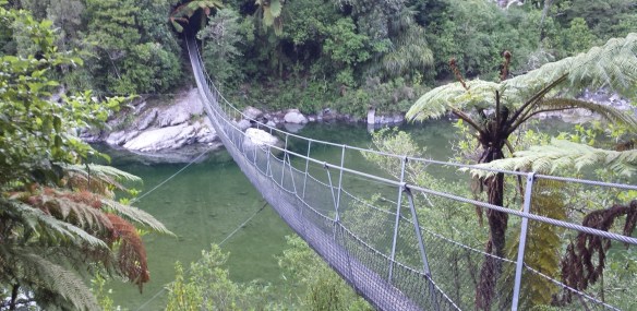 Another form of river crossing is the swing bridge. Not exactly a hazard (though perhaps people have come to grief on them), some who have not tramped in New Zealand before find them rather scary. The main thing in crossing is to avoid them actually swinging. So wait until anyone before you is off the bridge and it has stopped swaying. Then stow your poles, as they will only be a hindrance. Make sure they, and anything else on your pack, won’t catch on parts of the bridge as you cross, and secure your hat so it won’t blow away. Focus your eyes ahead and place one foot in front of the other. There is no need to look down at your feet, and doing so will only make you feel unstable. If necessary, a companion could carry your pack for you. If the experience was nerve-wracking, reward yourself with a piece of chocolate or a hug from a friend so you can face the next one with more confidence.
In a similar category, there are parts of the hike where you have narrow paths and steep drop-offs below you. These can be encountered on the Waiau Pass, the Richmond Range in particular, and in the Tararuas. Focus on where you are putting your hands and feet and not the drop below. You might want to stow one or both poles to free up your hands if you are clambering up or down a steep bit. And avoid being in such places in gale winds where you could be blown off.
Accidents
Just as most accidents happen around the home, most accidents on the trail are not dramatic falls off high cliffs or river drownings but mundane things like tripping over a tree root and falling or twisting an ankle on a rough patch. I fell over five times when walking the South Island, and each time I was just lucky that I was able to pick myself up and continue on.
There was the time, for instance, when I was on a steep slope and stepped on some tussock. It can be very slippery stuff and in an instant I was on my back with one leg twisted up behind me. No muscles or ligaments torn or sprained, but it could easily have been like an occasion several years earlier where I tore a calf muscle from end to end simply by taking an extended step up a small bank on a casual day walk. I heard a sort of pop and felt like someone had hit me on the back of the leg with a hammer. I was barely able to hobble back to the road-end and I ended up out of action for weeks.
What’s the message here? That possibly the greatest hazard is simply tiredness, and with it, inattention and bad judgment. If you are going for some really long days where you will end up on autopilot, do it road walking or other easy terrain where less can go wrong.
The NZ Mountain Safety Council has an interesting report on accidents. There have been 6 fatalities and over 3,000 injuries per year amongst trampers in recent times (that’s excluding hunters, climbers, etc), with 53% of tramping fatalities due to falls, and 18% in river crossings.
Cars and Guns
And then there are other sorts of accidents. Road walking is always dangerous. An average of 33 pedestrians per year are killed in New Zealand by vehicles, and 40% of those are in non-urban areas. That is, alongside highways and backcountry roads. Wear bright clothing, walk on the side of oncoming traffic and never walk at night. At blind corners I often cross to the outer corner where there is more chance of being seen and a wider road margin, even though I am no longer facing the traffic. NEVER wear headphones of course, or you won’t hear vehicles coming.
Wearing bright clothing may help you avoid dying in the bush, too. Not only will it be easier to spot if a search party is out looking for you, but there is a better chance you won’t be shot by mistake by a hunter. It does happen. There is about one accidental hunting shooting every 9 months in New Zealand. It is mostly other hunters who get hit and if you are on a well-established track you should be fairly safe (from intelligent hunters). Blue is said to be a good colour to wear because it is least likely to bear any resemblance to a deer compared to red, orange, brown, etc. Fluorescent orange is often worn by hunters, and can be seen a long way off, but some say that a moving patch of orange in dense bush can act attract a hasty shot in some circumstances as much as it protects the hunter in others.
Dogs
You will come across dogs barking furiously, but in general they are ones restrained on a property and they are just warning you to stay off their territory. If you are confronted by aggressive, unconstrained dogs the general advice is not to make eye contact, to stand still or back away (but don’t turn your back on them) and definitely don’t run, as that just triggers the hunting instinct to chase a prey animal, and you can’t outrun a dog. And don’t wave your arms around or scream and shout. Dogs get excited easily and can feed off each other’s excitement if there is more than one, as well as from your own level of agitation. So, basically, you want to de-escalate by not challenging the dog nor appearing as frightened prey. You can buy citronella or pepper sprays to repel dogs, but you need to be in fairly close range to use them. Aerosol horns that are sold as personal protection devices (against muggers) can also work, but the ultrasonic noise devices are more for training domestic pets.
When it comes to actual attacks, dogs can make a warning bite at your ankles, which is distressing but clearly not fatal. You can try and throw something like a drink bottle off to the side of a dog to distract it if it looks like it might attack. And use your pack or similar to put between yourself and an attacking dog. If things get serious, the places to hit a dog are in the face, neck or back of the head, but not on the top of the well-protected head. A dog attacks by trying to tear flesh by pulling away and vigorously shaking its head, so counterintuitive as it may seem, don’t try and pull an arm away if it is in the jaws of a dog – push towards it instead. The most serious attack can come from a pack of dogs. The pack leader will attack from the front while the others will circle behind you. If you can get the leader to back off the others will follow. And, if things get really bad, and you are on the ground, curl into a fetal position to protect your vital organs and bring your arms, with fingers in a fist, up over your neck and head. The chances of things getting to this state are extremely low in New Zealand, but one man was mauled to death by a pack of dogs in Northland in 2022, so they are not zero.
Header photo: St Arnaud Range, Nelson Lakes National Park
