
 Click on 3D map to enlarge, click again to zoom
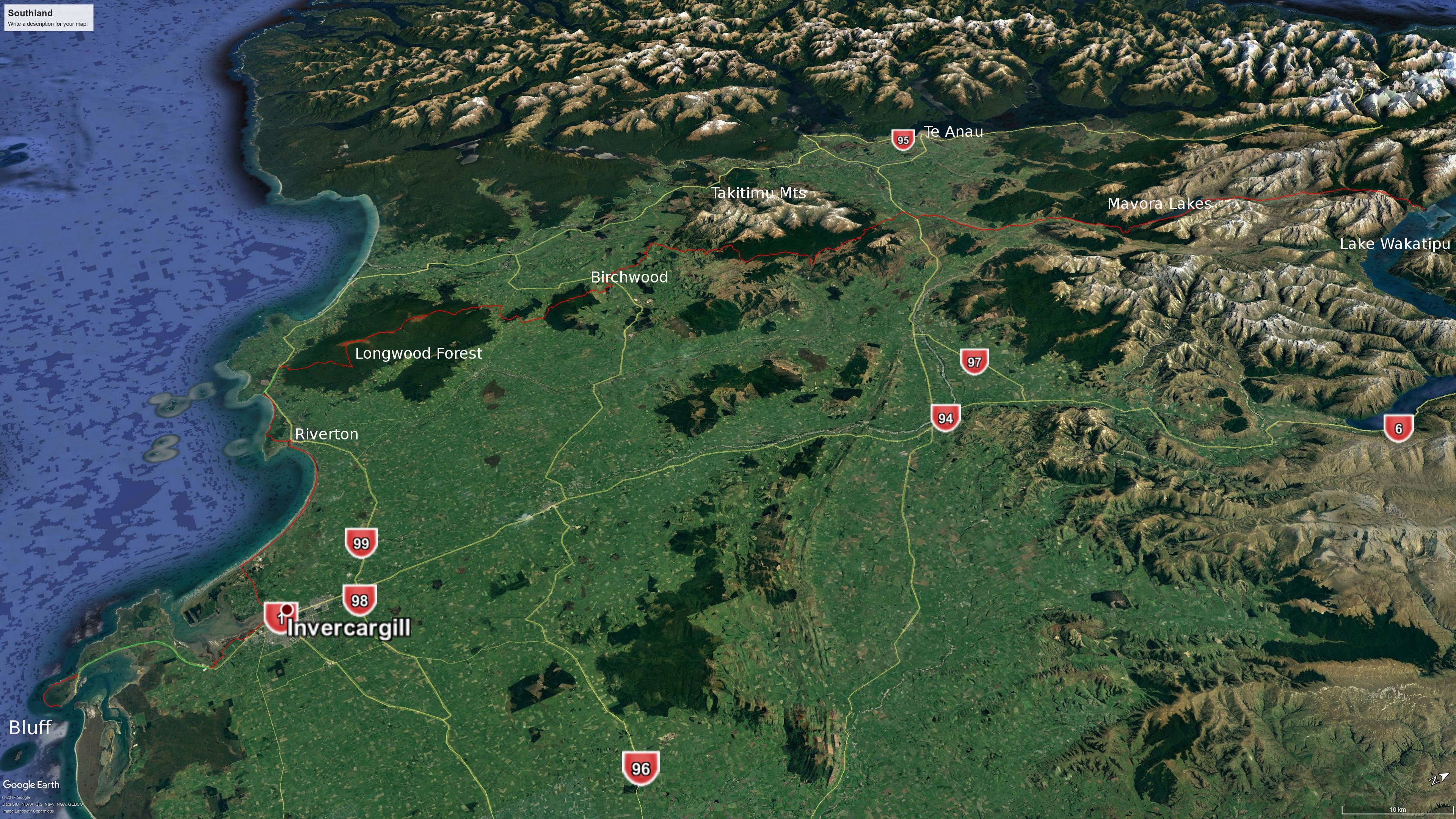
Bluff to Colac Bay: 79 km, 3 days
1. Bluff to Invercargill: 8.5 hrs, 34 km (maps 160, 159)
3D view west: Bluff to Invercargill
- Bluff Lodge – 120 Gore St, Bluff, 027 294 5306. A range of accommodation, including dorm rooms.
- Bluff Camping Ground – 21 Gregory St, Bluff, 027 626 2018. This is between the main centre and Stirling Point. Seems to be campervan dominated.
- Lands End Boutique Hotel – 10 Ward Parade, Stirling Point, Bluff, 03 212 7575. Fairly upmarket.
- Bluff Freedom Farm – 6 Nichol Rd, Bluff. Tent sites and a communal cabin. Rural location, kayaks for use, pay by koha, bookings not necessary. Jasper jaxxxer@gmail.com.
First off, consider whether you need to stay overnight in Bluff. Bluff looks like it could be a very nice place to stay, but an alternative, which will save you carrying all your gear, is to stay overnight in Invercargill the night before, leave most of the contents of your pack there, and catch a shuttle to Bluff early in the morning with only what you need for a day walk. The shuttle will take you right to the start point, Stirling Point, where there is the famous signpost pointing to distant cities all over the world. Remember to get your photograph taken here!
The official route is now up to the top of The Bluff / Motupohue on Topuni Track and then down the other side on Millennium Track. Or if you want to conserve energy and are not bothered about having a hilltop view you can follow the previous TA route on the track around the south side of The Bluff. Either one is is followed by farmland that is periodically closed to walkers due to dangerous cattle. Check the ‘Trail Status’ page on the official TA site.
You are lucky, because the long awaited cycle/walking path called Te Ara Taurapa from Bluff to Invercargill has finally been completed. The section from Bluff through to the fertiliser works was one of the most unpleasant and dangerous on the whole trail and NoBos were treated to a trial by fire in having to walk the 16km of busy road edge here. The new section of the path meets the previously constructed one at the fertiliser works. I’m not exactly sure how seamless the connection between new and old is, but the section to Invercargill starts a few metres over the railway line on Kekeno Pl at the left of the main road past the works. Note that there is little shelter or shade on the whole route, and no drinking water sources. There is a toilet at Stirling Point, the start/end of the TA Trail, and one just before you get into Invercargill, near the Bond St carpark on the Estuary Walkway. I don’t think there are any between these points.
Invercargill has two major supermarkets close to each other, Pak’nSave at 95 Tay St, and New World at 244 Elles Rd (as well as Woolworths at 172 Tay St). Plus there are Kathmandu (50 Leven St), Macpac (48 Tay St) and Southern Adventure (31 Tay St) stores for hiking supplies, including gas at Macpac and Southern Adventure, as well as hardware stores such as Bunnings and Mitre 10, but apparently not at Placemakers. Southern Adventure is a non-profit store(!) run by the Scouting Southland Trust and is the last remaining Scout Shop in NZ. Worth your patronage I reckon.
- Tuatara Lodge – 30-32 Dee St, close to the centre of town – 0800 488 28272; 03 214 0954.
- Southern Comfort Backpackers – 30 Thomson St, 027 524 9926. Includes female-only dorm. North of the centre and abut 1km from the nearest large supermarket.
- Central City Camping Park – 209 Tweed St, 0508 CAMPING, 03 214 2226. Remarkably central and with free wifi and cabins.
- Catch-a-Bus South – 027 4497 994. They go from Invercargill to Bluff at 6.15am and 8.30 am daily, as well as other times through the day until the last service at 6.30pm. The 6.15 am and 6.30pm ones are more expensive. Pickup is from your accommodation. They can also take your pack alone for a fee. They go from Dunedin to Invercargill daily in the early afternoon too.
- RealNZ 03 249 6000; 0800 656 501. They run a bus service to Bluff that connects with the Stewart Island ferry. You will need to phone them to see if they can take you on their bus without the ferry booking though, as there is no way to book this separately on their website. Bus departs Invercargill 8.15am and 3.30pm.
2. Invercargill to Riverton / Aparima: 8 hrs, 32 km (maps 159, 158, 157, 156)
3D view south: Invercargill to Colac Bay
The route out to Oreiti Beach is straightforward, along a roadside, often with decent margins to give you some distance from the traffic. There are a number of reserves with toilets and cafés along the road, as well as a small Four Square store about three quarters of the way.
The beach is one long, exposed slog, with no shelter. You could potentially camp amongst the sand dunes, though they are low and offer little shelter from the wind, or water. Crossing the Waimataku River half way along the beach may be a problem at high tide according to the official track notes.
If you want to make an easy walk even easier you can pay ODF Transport to take your pack. Their truck leaves Invercargill for Riverton at 12.30pm on weekdays. And The Riverton Freight Van goes at 10.30 and 3.30pm. Contact Danyon Cleaver, 027 236 9753.
Riverton / Aparima: The Riverton Lodge Hotel is operated by a very nice couple. It is run down, but in a pleasant and comfortable way. There are several good cafés in town, a small supermarket, a museum, and a takeaway food shop. One could easily linger in Riverton.
- Riverton Holiday Park – 43 Richard St, Riverton, 03 234 8132; 027 617 9290. Ten or 15 minutes out of town on the way to Mores Reserve.
- La Riviera Guesthouse – 136 Palmerston St, Riverton, 027 459 5669, (just two apartments, so not cheap I think).
- Riverton Lodge Hotel and Backpackers – 57 Princess Street, Riverton, 03 234 9945. Double rooms, dorm room and camping. Recommended.
- Fresh Choice Supermarket – 163 Palmerston St.
3. Riverton / Aparima to Colac Bay / Ōraka: 4.5 hrs, 13 km (maps 156, 155)
Cross the bridge heading out of town, turn left around the estuary, and right up Richard St. A sign marks Mores Reserve. There is a toilet at the reserve car park. Take the Mores Track loop. It has a TA sign. Two minutes or so up is a track to the left to the lookout. It is not far and is worth visiting for the view. The track to the coast on the other side of the hill is a pleasant walk through low bush. After some time over farmland and sections of rocky coast you reach Colac Bay (the farmland is closed September to October for lambing). The walking on this beach is less firm than Oreti Beach, making progress tiring and slow. Towards the end a road back from the beach makes a respite from struggling on the sand and stones. The Colac Bay settlement is very small. The only shop is at the campground and there are few other accommodation options.
- Luna Sea Lodge – 641 Orepuki–Riverton Highway, a little inland from the eastern end of Colac Bay beach after you leave the rocks for sand (go up western end of Tīhaka Beach Rd), only about 8 km from Riverton Holiday Park. Individual rooms with shared facilities. 027 601 5744, lunasealodge@gmail.com
- Colac Bay Bakehouse and Café & Camping Ground – This property changed hands in 2025 and is being redeveloped. Accommodation is available again at the campground (tent sites and cabins), the shop is operating, and the former tavern is now operating as a bakery and café. 022 639 5928 (Lewis).
Longwood Forest: 57 km, 2 days
3D view south-west: Colac Bay to Merrivale
4. Colac Bay to Martins Hut: 7 hrs, 16.5 km (map 155)
The next two days are through the Longwood Forest. (It is the deer shooting season in March/April here, so best to wear a high visibility pack cover to avoid getting shot by mistake then.) Continue inland on the road that brought you from the beach for about an 1hr to arrive at the Long Hilly Track car park. There is little traffic along the road. The car park has a toilet. The Long Hilly Track is easy to begin with. You then head uphill, climbing about 320m to reach the 2-bunk, run-down Turnbull’s (Big Dam) Hut and on to Martins Hut. Note the several tracks branching after Turnbull’s Hut – keep left.
The alternative is the earlier TA route of 29.5km and 9hrs. This goes around the side of the hill on the Ports Water Race Track off to the right. It was a bit muddy and had many fallen trees when I did it, but it does have historical interest, as it follows a water race constructed mostly by Chinese gold miners in the 1880s and 1890s. It also has less uphill walking. If you take this track, it eventually meets a bush road. Turn left uphill and take the right fork when the road divides. The track off the road to Martins Hut is clearly marked.
- Martins Hut – Basic 4-bunk DoC hut. Free to stay. The hut has a water tank, but if it seems dodgy, the official track notes say: “Another water source at Martins Hut is small stream off on an unmarked side track between the toilet and the hut. This is off to the left as you are facing downhill”. Martins Hut was constructed in 1905 to house a water race maintenance worker. Yes, that’s one worker: the hut is very small. There isn’t any flat ground around it for camping.
5. Martins Hut to Merrivale Rd intersection: 10 hrs, 28.5 km (maps 154, 153)
After going uphill from Martin’s Hut you come out onto the scrub covered Longwood ridge. Marker poles along this boggy ridge are spaced well apart and would be hard to follow in low visibility. It can be pretty muddy across this top and the TA Trust have a plan to build a boardwalk. You can donate here. The track then descends to an abandoned quarry and joins up with a road that heads steeply uphill to the Bald Hill transmission tower. Keep on the road all the way to the top and don’t be put off by the locked gate, nor deceived by a marker pole that appears to lead to a route off the road. There is water in small trickles on the right-hand side of the road. There is also good cell phone reception at Bald Hill. There could be a place to camp 1 km or so north of the hilltop at the margin with bush cover. No water, so get some earlier.
The rest of the track continues to the Merrivale Rd end. There are several options now for a place to sleep. One is camping: there is room for about one tent where the track exits from the trees onto farmland, but there is no water source. Dense vegetation either side of the road makes camping in the area difficult in general. However, you can continue down the road until you reach another road coming in from the right. A short distance down this there are flat patches on the margins of the road that will take a tent at a pinch – just before a substantial stream that crosses the road. A much better option is to arrange accommodation at Merrivale Hut, 5km downhill at the intersection of Merrivale Rd and the main road between Otautau and Tuatapere. Or you could hitchhike to either of these settlements. Tuatapere is about 26k to the west, Otautau 16k to the east. However, this will make for a very long day, and traffic may be very light if you reach the road during the evening.
- Merriview Hut – 2 Merrivale Rd, Otautau, 021 567 105, merriviewhut@gmail.com. $15 or camping $10pp.
- Otautau Hotel – 167 Main St, Otautau, 03 225 8166; 021 0411 837. Includes rooms, bars & restaurant. Accommodation bookings to be made on Booking.com. Single room $100, double $130 (Sept 2025).
- Otautau Railway Hotel and Backpackers – 76-78 King St, Otautau, 03 225 8577. Backpackers, bar & restaurant.
- Tui Base Camp – 4 McFeely Street, Tuatapere, 03 226 6250; 027 837 3521.
- The Cwtch – 6 Ferry Rd, Tuatapere, 027 683 0670 (Greg). 4 Bunks in historic community hall. $30pp, or koha for TA walkers.
- Last Light Lodge aka Hump Track Backpackers – 6 Clifden Rd, Tuatapere, 03 226 6667, 022 105 1664. Includes backpacker accommodation, camping, restaurant/café. Book on Booking.com if the website won’t work.
Both Otautau and Tuatapere have a small supermarket.
Inland Bush and Woodlaw Forest: 26 km, 1 day
3D view south-west: Merrivale to Telford Burn
6. Merrivale Rd intersection to Birchwood (Struan Flat Rd): 8 hrs, 27 km (maps 153, 152)
Turn right from Merrivale Rd on to the Otautau–Tuatapere Rd. You need to look for an overbridge over a farm road. There is apparently a TA marker somewhere before this, and a stile, but if you don’t spot it just get onto this farm road and go uphill and through two farm gates to the Inland Bush track. The second gate has an orange marker on it. Further markers follow a steep track up through bush. Near the top, just as you are about to leave the bush and enter farmland again, is a track to the right that is marked. This soon becomes a forest road through pine forest and the walking becomes very easy. No camping or fires are permitted in the forest.
After exiting the pine forest it is less than an hour’s walk along pleasant country roads with little traffic to the well-marked turn-off to another hill with a pine forest. You can keep walking another 1 km along the road to the Gampsie Downs accommodation if you didn’t stay at Merrivale Hut.
- Campsie Downs – 324 Scotts Gap–Feldwick Rd. Two sets of bunks, toilets, hot showers, kitchen, frozen meals available for purchase and vegetable garden to help yourself. $20 Text Rowena 027 577 0978. (Confirmed correct Oct 2024)
The climb up the Woodlaw Forest hill is steep, but it eventually becomes a 4WD forestry road along the top, where the walking is easy. There is one small stream in the bush on the way up. Otherwise there is no source of water for this entire day. And again, no camping or fires permitted in the forest. After passing below some cellphone towers the road meets farmland. (Note that this farm is closed to walkers from 9 September to 9 November for lambing.) Take the fence-line on the right-hand side downhill. There are occasional markers, but they are very distantly spaced. Then the fence meets another at right angles; take the right-hand one down an extremely steep hill. This would be almost impossible to descend safely when wet, especially without walking poles. Which side of the fence you should be walking on is unclear and maybe it doesn’t matter. You are heading for the middle of a long eucalyptus forest where the young trees meet the mature ones. The track goes alongside this plantation to the left, turns right, and reaches the Birchwood-Wairio Rd. Ohai is 7km down the road but note that there are no shops there.
- Birchwood Station cabin for TA walkers – Near Birchwood. Call ahead for directions on how to get there exactly. $20pp for the night and $20 more for a pizza (check ahead for availability). Gas cooking facilities, microwave, hot shower, fire, toilet. Call or text Sarah (preferably) 027 699 5234, or Dean on 021 655 852 if you can’t get her. They will accept parcels. (Note that this Birchwood Station cabin is entirely different from the Ahuriri River Lodge at an entirely different Birchwood Station many kilometres to the north.) (Confirmed correct Oct 2024)
- Nightcaps is 9 km east of Ohai and has a Four Square store but apparently no accommodation. Tuatapere, 38 km south-west of Ohai, is your only other accommodation option in the region (see above for listings), unless you camp on farmland (with permission).
Takitimu Mountains: 70 km, 3–4 days
3D view west: Telford Burn to Princhester Rd
7. Birchwood to Lower Wairaki Hut: 14 hrs, 40 km (maps 152, 151)
This route is over Mt Linton Station and access is only permitted during daylight hours and no camping is allowed. Keep to the route and give way to farm operations. There have been problems with hikers going off the marked route. Farm management will consider this trespassing and act accordingly – don’t ruin it for others! The land is closed from 25 September to 5 November for lambing. You can take an alternative route from Dunrobin Rd (south of Mossburn & a considerable detour) to Aparima Hut at this time. There is little water for most of the route.
Birchwood (Struan Flat Rd) to Telford Burn: 10 hrs, 32 km
This section has changed several times since I walked it, perhaps due to problems with hikers. So my notes are simply taken from reading the TA map and a satellite view. You start by heading uphill along the side of a patch of trees, then left to go under the transmission lines to a large pond. From there you head back towards the power lines and roughly follow them for 1.5 km, before going northwest and meeting up with a long fence line with trees or hedges. This eventually takes you close to the Wairaki River, which you follow upstream and then cross. Two km later you go up a valley at left. (There is a swing bridge about 3km further up if it is too dangerous to cross, BUT this is off the trail, and you should get permission to take this route first.)
You follow a farm road to reach Telford Burn. 800m or so up you ford it at the marked spot; another km further is Telford Burn campsite. (‘Burn’ doesn’t here mean a burnt patch, but is a Scottish term for a steam, reflecting the Scottish origins of many early European settlers to the lower South Island). You will know when you have arrived because there is a round, plastic toilet right in the middle of nowhere. There are large trees dotted about the field nearby, which offer ideal shelter for camping beneath, but the water in the small stream nearby runs through farmland, so should perhaps be treated. It’s a nice spot to camp, but fairly exposed to wind and can be boggy after rain. You could push on to Lower Wairaki Hut if you are making good time, but this next bit is tough.
Telford Burn to Lower Wairaki Hut: 4 hrs, 8 km
It is a very hard climb above Telford Burn. The markers seem to suggest you go into the bush on the way up, but ignore that. Begin on the opposite side of the fence line from the campsite and you will find markers further up: keep going straight up whether you can see the markers or not. The climb to and along the Telford ridge tops is very exposed and would not be safe in a storm. The highest point is 1024m. On the other hand, the descent down the other side is through the Takitimu forest and is easy going. The exit from the tops into the forest is well marked.
- Lower Wairaki Hut – Basic 4-bunk DoC hut. Free to stay.
8. Lower Wairaki Hut to Aparima Hut: 5.5 hrs, 13 km (maps 151, 150)
The track is through dense tussock at times. The trail may be faint and it can be hard to see the next marker (a common issue on further sections of the TA), so you need to pay attention. Other parts are through forest.
- Aparima Hut – Standard 12-bunk DoC hut. This is very nicely situated above a small river with a good swimming hole. There is a large flat grassed area around the hut and it gets plentiful sun. It’s worth getting there early so you can enjoy the place. There is an older, run-down hut also with 6 bunks at the back of Aparima Hut.
9. Aparima Hut to Lower Princhester Hut: 7 hrs, 17 km (map 150)
This involves further travel through a mix of forest and tussock, and once again it can be difficult to find the track. The TA map departs in places from the NZ Topo Map marked track as well, but presumably the former is more reliable. Lower Princhester Hut is not on a DoC signpost here, and neither is it at the next sign, for Spence Hut. A well-hidden marker is at the bush margin near this sign at the right, marking the trail down the valley. Later, at a point where it may be hard to see any markers, the valley forks. Take the left one and markers soon appear.
- Lower Princhester Hut – Standard 6-bunk, DoC hut.
10. Lower Princhester Hut to SH94 and Te Anau: 1.5 hrs, 6 km (maps 150, 149)
This is along a gravelled country road which then joins SH94 at a spot known as The Key. There is a coffee caravan called the Sprig & Thistle at this intersection. It is open from 7 Oct (2025) Tues–Fri 7am to 3pm, Sat 8am to 2pm, and Sundays from mid-Nov (I think it closes for the winter). From this point it is 20 km to the right to Mossburn and 35km to the left to Te Anau. Shuttle buses such as Tracknet travel along this road and will pick you up if you have made a prior arrangement. It is also a densely travelled tourist road, but much of the traffic is tour buses and campervans, so it can be hard to hitchhike. A stop in Te Anau is useful for resupply, plus a shower and rest, as otherwise you would be carrying food for quite a few days before Queenstown. There doesn’t seem a lot of point going to Mossburn as Te Anau has many more accommodation, supermarket and eating options.
There are several outdoors stores in Te Anau, and being a tourist town, they stay open quite late. Outside Sports, on the main street (curiously, but logically named Town Centre) next to the Four Square store has all the big brands. Fiordland Frontier Supplies, off to the side of Town Centre, further away from the lake on the opposite side, is more hunting oriented, but consequently has different, and less mass-market, gear. There are plenty of cafés, takeaway joints and restaurants.
- Te Anau Lakefront Backpackers – 48-50 Lakefront Dr, Te Anau, 03 249 7713, 0800 200 074. Well located.
- Te Anau Central Backpackers – 26 Mokonui St, Te Anau. 03 218 9034. Formerly Te Anau YHA. Well located near town centre.
- Rosies Backpackers and Homestay – 23 Tom Plato Drive, 03 249 8431, (less central but highly rated).
- Te Anau Top 10 Holiday Park – 15 Luxmore Dr, Te Anau, 03 249 8538.
- Te Anau Lake View Kiwi Holiday Park & Motels – 77 Manapouri–Te Anau Highway, 03 249-7457; 0800 483 262. Includes BBH backpacker dorms, twin/double and single rooms branded as Steamers Beach Backpackers. Near DoC visitor centre and is depot for Tracknet shuttles. Is further from Town Centre than the other accommodations.
- Fiordland I-SITE Visitor Centre – 80 Lakefront Dr, Te Anau, 03 249 7516, info@fiordland.org.nz
- DOC Te Rua-o-te-moko / Fiordland National Park Visitor Centre – Cnr Lakefront Dr and SH95 Manapouri highway, about 10 mins walk from Te Anau town centre, 03 249 7924.
- Intercity Coachlines – 03 365 1113, daily buses to Queenstown, Dunedin and Christchurch.
- Tracknet – 0800 483 262; 03 249 7777, res@tracknet.net Daily departures at 7.00 and 11.30 passing Princhester Bridge. Returning trips passing the same point at 8.50am, 12.20, 6.20pm but best to check this as the online timetable currently doesn’t give the pickup times. $32 each way.
- Topline Tours – This may be another option to get to and from Te Anau and Princester Bridge is with Linda and Denis. They have a 9-searter mini-van and a car and operate on request. 03 249 8059, 03 249 9550, or try 029 770 3134 (Linda). (Confirmed correct, Oct 2024)
- Four Square Supermarket – 30 Town Centre, Te Anau
- Fresh Choice Supermarket – 5 Milford Cres, Te Anau
- Mossburn Railway Hotel – Cnr York and Bath St, 03 248 6399. Pub-style accommodation, bar and restaurant (restaurant closed Mondays).
- Mossburn Country Park – 333 Mossburn–Five Rivers Rd, 3 kms north of Mossburn. Cabins and campsites. 03 248 6444.
- Four Square – 37 Devon St, Mossburn.
Mavora Lakes – Greenstone Walkway: 96 km, 4 days
11. SH94 Princhester road to Kiwi Burn Hut: 8 hrs 15, 30 km (via river track) (maps 149, 148)
3D view west: Princhester Rd to Mavora Lakes
The two Mavora Lakes are a popular area for camping, fishing, boating, horse riding, trail biking, and 4WD activities.
You can catch a shuttle from Te Anau to the point you joined SH94 from Lower Princhester Hut, or hitchhike, then walk east along the main road to the gravel country road that turns off at left. You have two choices: turn off the road after about 11 km to follow along the Mavora River. Hikers say that this is a difficult walk through long grass and swampy patches and the official TA site now also concedes that it is overgrown. The alternative is to continue on the road and cut across farmland when you think you are about opposite the valley for Kiwi Burn Hut. Preferable in terms of respect for landowners, is to use one of the angler access points you see signposted now and then along the road to reach the river. Reaching Kiwi Burn Hut means fording the Mavora River whichever way you travel, and if this is high, then you need to continue about another 3 km to cross a swing bridge (there is a track to this from the road), and then turn back down river for the 3 km to reach the track to Kiwi Burn Hut (1.5 km from the river).
- Kiwi Burn Hut – Standard 12-bunk DoC hut.
12. Kiwi Burn Hut to Boundary Hut (8 bunks – as 4 doubles): 8 hrs 15, 33 km (maps 148, 147, 146)
3D view west: Mavora Lakes to Greenstone
From Kiwi Burn Hut head back to near the Mavora River again and then north on the track to South Mavora Lake, where you will pass the above-mentioned swing bridge, then another at the lake (3 hrs 15). Don’t cross the swing bridge but continue north along the lakeside to the campsite at the North Mavora Lake (1.5 hrs). The campsite is mostly used by people with 4WDs or campervans and is very popular in summer. There are plenty of trees, toilets and a shelter. A fee is payable via an honesty box.
The shore a little north of the camp ground is a Lord of the Rings site where the Fellowship end their Anduin River journey (grid ref 1221 / 4976; S45°15.993′, E168°10.410′). Nearby in the forest is also the area where Merry and Pippin hide from the Uruk-hai.
It is then another 2 hrs 15 (6 km) to Carey’s Hut along 4WD roads on the east side of the lake. Carey’s Hut (7 bunks) is a pleasant, though run-down, hut. It has a wood burning shower but this is apparently defunct and there is little chance of finding firewood anyway. You could stop here or push on along the road Boundary Hut (1.5 hrs). The turn-off to the hut is not marked but the hut is visible on the left from the road.
- Boundary Hut – Standard 4-(double) bunk DoC hut.
13. Boundary Hut to Greenstone Hut (20 bunks): 6.5 hrs, 22 km (maps 146, 145)
Leave the hut and cross the river via the swing bridge. After 3.5 hours over open country you will reach another swing bridge and Taipō Hut (8 bunks). 3 km north of the hut the track splits into two routes to Greenstone Hut. Keep to the left-hand one. The right-hand track becomes poorly marked, rough, and indistinct (though a hiker reported a huge amount of tree fall on the left-hand one in Nov 2023, so you might want to ask any SoBos you come across about this.)
- Greenstone Hut – Serviced 20-bunk DoC hut. DoC Hut Pass not valid in summer, and 20% discount only for TA Trail Pass. Bookings required. This is a popular hut on the Greenstone-Caples track, with a warden in summer. You can camp outside and bookings are also required for this.
14. Greenstone Hut to Greenstone car park end: 3 hrs, 11 km (map 145)
The track to the Greenstone road end on Lake Wakatipu is easy walking through attractive bush. Many day walkers may be encountered. From the road end you can catch a shuttle to Glenorchy and then around the lake to Queenstown. The official TA position is that it is not necessary to walk the route because Queenstown is about the same latitude as the road end, and it would simply be one long road walk anyway. Shuttles may or may not be willing to pick up unbooked passengers at the road end. They tend to operate on demand – if there are no bookings then they don’t drive. And they usually need 2 people for a trip. If it is just you, then you pay for two people. You may be able to pick up a ride with one of the day walkers to Glenorchy. And from there it is a busy road to Queenstown.
Greenstone car park to Queenstown: about 1.5 hrs driving
- Kinloch Wilderness Retreat – 862 Kinloch Rd, Kinloch, on the road from the Greenstone car park to Glenorchy. This was formerly YHA Kinloch, and was such a fantastic location for a hostel that it was sold during Covid to become this upmarket retreat. There are 2 rooms of bunks, but they are an expensive $75 each. 03 442 4900.
- Kinloch Campsite – If you are not hankering to get to Queenstown or Glenorchy for resupply there is a DoC campsite on the road before Glenorchy that is included in the TA Trail Pass.
- Twelve Mile Delta Campsite – Likewise, there is this DoC campsite 12 km before Queenstown. This one isn’t included in the Trail Pass.
- Glenorchy Hotel & Backpackers Retreat, Information Centre and General Store – Mull St, Glenorchy, 03 442 9902.
- The Headwaters Eco Lodge – 34 Oban St, near info centre, cabins, bunkrooms, camping. ‘Designed, built, and operated in line with the philosophy and principles of the Living Building Challenge, the most stringent environmental building design certification in the world.’ Upmarket, rustic look and priced accordingly (Quad Room of 4 bunks is $440 for the room as at Sept 2025). 03-409-0401.
- Mrs Woolly’s Campground – 64 Oban St, 021 0889 4008. Falls under the same organisational umbrella of the above (as ‘The Headwaters’) and share the same phone number of 03 409 0401.
- Glenorchy Motels (formerly Mt Earnslaw Motels) – 87–89 Oban St, Glenorchy, 027 436 8531.
- Info&track – (Formerly Glenorchy Journeys.) Greenstone car park depart 10:15am, 12:45pm to Glenorchy $46; Glenorchy to Queenstown 10:15am, 3pm, 6pm, $39. (Or $72 for Greenstone to Queenstown, which will involve a forced stop in Glenorchy. You may as well get the 12.45pm shuttle at Greenstone to minimise hanging around spending money at Glenorchy for 3 or 4 hours. The trip from Glenorchy to Queenstown is about 45 mins). shop@infotrack.co.nz; 0800-462 248; 03-442 9708.
Queenstown (accommodation can be very scarce here, so book well ahead)
- Haka House Queenstown Lakefront – 88-90 Lake Esplanade, 021 639 796. It is a little way from the centre, but only by 500m or so. It is big, clean, high-throughput, and well equipped.
- Haka House Queenstown – 6 Henry St, 021 225 6939. Back just a little from the CBD and close to the Four Square supermarket.
- There are other backpackers amongst a whole plethora of accommodation in Queenstown. Some of the most central are Lylo, Nomads, Southern Laughter and Absoloot. Slightly further out are the Flaming Kiwi, Hippo Lodge, Aspen Lodge, Adventure Q2, and the Black Sheep, amongst others.
- Creeksyde Queenstown Holiday Park & Motels – 54 Robins Rd (about 600m from the centre of town along Gorge Rd), 0800 786 222; 03 442 9447.
- Fresh Choice Supermarket – 64 George St, Queenstown (about 500m from the CBD).
- Mediterranean Food Market – 53 Robins Rd, Queenstown.
- Alpine Four Square Supermarket – Cnr Shotover & Stanley streets, Queenstown.
- Out of town on the TA route (see Otago page): There are giant supermarkets at Frankton. For example, New World and Pak’nSave on Hawthorne Dr and Woolworths on Grant Rd.
- Ritchies Transport run a regular service to and from Wānaka if that is of use to you.
– Always check the Trail Status pages of the official Te Araroa website for recent changes or alerts on the trail.
– To download this page see instructions on the Home page.
– Make a donation to support this site.
Last updated 3 March 2026
Header photo: Colac Bay
